White Sands, Alberta facts for kids
Quick facts for kids
White Sands
|
||
|---|---|---|
|
Summer village
|
||
| Summer Village of White Sands | ||

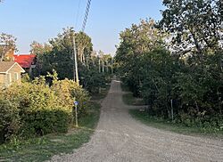
Lakeview Ave and 2nd Street in White Sands
|
||
|
||
| Country | Canada | |
| Province | Alberta | |
| Census division | No. 7 | |
| Incorporated | January 01, 1980 | |
| Government | ||
| • Type | Municipal incorporation | |
| Area
(2021)
|
||
| • Land | 1.61 km2 (0.62 sq mi) | |
| Population
(2021)
|
||
| • Total | 174 | |
| • Density | 108.1/km2 (280/sq mi) | |
| Time zone | UTC−7 (MST) | |
| • Summer (DST) | UTC−6 (MDT) | |
White Sands is a special kind of community in Alberta, Canada. It's called a "summer village." This means many people live there mostly during the warmer months, like a vacation spot! It sits right on the southeast side of a beautiful place called Buffalo Lake. You can find it northwest of the town of Stettler. It's also east of another summer village, Rochon Sands, and Rochon Sands Provincial Park. White Sands is part of a larger area known as the County of Stettler No. 6.
White Sands Population
Every few years, Canada counts how many people live in different places. This is called a census. It helps us understand how communities are growing.
Population in 2021
In the year 2021, a group called Statistics Canada counted the people in White Sands. They found that 174 people lived there. These people lived in 82 homes. This was a big jump from the 120 people who lived there in 2016.
The land area of White Sands is about 1.61 square kilometers. This means there were about 108 people living in each square kilometer in 2021.
Population in 2016
Back in 2016, the census showed that 120 people lived in White Sands. They lived in 59 homes. This was also a good increase from the 91 people counted in 2011.
The land area in 2016 was slightly smaller, about 1.58 square kilometers.
 | Stephanie Wilson |
 | Charles Bolden |
 | Ronald McNair |
 | Frederick D. Gregory |


