Whiteriver, Arizona facts for kids
Quick facts for kids
Whiteriver, Arizona
|
|
|---|---|

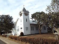
Historic Lutheran Apache Mission
|
|

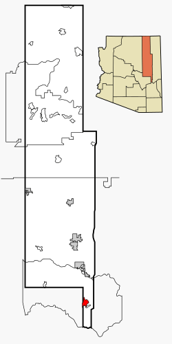
Location in Navajo County and the state of Arizona
|
|
| Country | United States |
| State | Arizona |
| County | Navajo |
| Area | |
| • Total | 15.80 sq mi (40.91 km2) |
| • Land | 15.69 sq mi (40.63 km2) |
| • Water | 0.11 sq mi (0.28 km2) |
| Elevation | 5,164 ft (1,574 m) |
| Population
(2020)
|
|
| • Total | 4,520 |
| • Density | 288.14/sq mi (111.25/km2) |
| Time zone | UTC−7 (MST) |
| ZIP code |
85941
|
| Area code(s) | 928 |
| FIPS code | 04-82530 |
| GNIS ID(s) | 2409588 |
Whiteriver (also known as Western Apache: Chʼilwózh in the Apache language) is a special kind of community in Arizona. It's located on the Fort Apache Indian Reservation in Navajo County. In 2010, about 4,104 people lived here, making it the biggest town on the reservation. By 2020, the population grew to 4,520 people.
Contents
Where is Whiteriver Located?
Whiteriver is found at a specific spot on the map: 33.833005 degrees North and -109.974547 degrees West. This means it's in the northern part of the world, west of the main line that divides the Earth.
The area of Whiteriver is about 17.8 square miles (46 square kilometers). All of this area is land, meaning there are no large lakes or rivers within its official boundaries.
How Many People Live in Whiteriver?
The number of people living in Whiteriver has changed over the years. Take a look at the chart below to see how the population has grown and shrunk:
|
||||||||||||||||||||||||||||||||
In the year 2000, there were 5,220 people living in Whiteriver. These people lived in 1,249 different homes. Many homes, about 56.4%, had children under 18 living there. The average household had about 4.10 people.
The people in Whiteriver are quite young! In 2000, almost half of the population (44.4%) was under 18 years old. The average age of people living here was 21 years old.
Beliefs and Religions in Whiteriver
In 2005, a study showed that the number of people on the Apache Reservation who followed traditional beliefs or no religion had decreased. At that time, about 43% of the population identified with these groups. On the other hand, 53% of the people living there considered themselves Christian.
Getting Around Whiteriver
Whiteriver has its own airport called Whiteriver Airport. This airport is used by small planes and is located just a short distance southwest of the town's center.
The White Mountain Apache Tribe also helps people get around. They run a local bus service called the Fort Apache Connection Transit. This makes it easier for people to travel within the area.
Schools in Whiteriver
Students in Whiteriver attend schools that are part of the Whiteriver Unified School District.
- Alchesay High School is the main high school for teenagers in Whiteriver.
- East Fork Lutheran School is another option. It's a Christian school that teaches students from elementary grades all the way through high school. It is part of the Wisconsin Evangelical Lutheran Synod.
Whiteriver's Weather
The weather in Whiteriver changes throughout the year. Here's a look at the average temperatures and how much rain or snow the area gets:
See also
|
||||||||||||||||||||||||||||||||||||||||||||||||||||||||||||||||||||||||||||||||||||||||||||||||||||||||||||||||||||||||||||||||||||||||||||||||||||||||||


 In Spanish: