Whiting River (Connecticut) facts for kids
Quick facts for kids Whiting River |
|
|---|---|

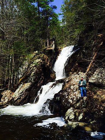
Campbell Falls on the Whiting River
|
|
| Country | United States |
| States | Massachusetts, Connecticut |
| Towns | New Marlborough, Massachusetts, North Canaan, Connecticut |
| Physical characteristics | |
| Main source | Thousand Acre Swamp New Marlborough, Massachusetts 1,388 ft (423 m) (42°04′00″N 73°12′40″W / 42.0667589°N 73.2112227°W) |
| River mouth | Blackberry River North Canaan, Connecticut 748 ft (228 m) (42°00′40″N 73°16′26″W / 42.0111111°N 73.2738889°W) |
| Length | 7 mi (11 km) |
| Width |
|
| Depth |
|
| Basin features | |
| River system | Housatonic |
| Basin size | 12,464.23 acres (5,044.09 ha) |
| Tributaries |
|
The Whiting River is a stream that flows south through parts of Massachusetts and Connecticut in the United States. It starts in a place called Thousand Acre Swamp in New Marlborough. The river then travels about seven miles (11 km) before joining the Blackberry River in North Canaan.
As it flows, the Whiting River takes a curvy path, heading southwest for about four miles (6.4 km) in Massachusetts. Along the way, it creates the amazing 100-foot (30 m) high Campbell Falls, which is part of Campbell Falls State Park Reserve. Another small stream, Ginger Creek, also joins the Whiting River in this area. After crossing into Connecticut, the river continues south for nearly three miles (4.8 km) until it reaches the Blackberry River.
What is a Watershed?
A watershed is like a big bowl that collects all the rain and snowmelt in an area, directing it into a river or lake. The Whiting River's watershed includes all the land that drains water into the river.
The Whiting River's Watershed Area
The Whiting River's watershed covers many marshy areas in southern New Marlborough. These include natural wetlands like Wolf Swamp, Thousand Acre Swamp, East Indies Pond, and Hay Meadow Pond. The river also gets water from two lakes that people created: Cookson Pond and Windemere Lake, both located in Massachusetts.
 | Shirley Ann Jackson |
 | Garett Morgan |
 | J. Ernest Wilkins Jr. |
 | Elijah McCoy |

