Whittemore, Michigan facts for kids
Quick facts for kids
Whittemore, Michigan
|
|
|---|---|
| City of Whittemore | |

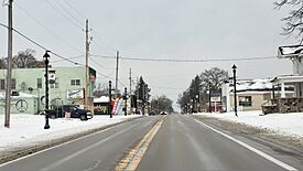
Looking north along S. Bullock Street (M-65)
|
|

Location within Iosco County
|
|
| Country | United States |
| State | Michigan |
| County | Iosco |
| Settled | 1879 |
| Incorporated | 1907 |
| Area | |
| • Total | 1.02 sq mi (2.65 km2) |
| • Land | 1.02 sq mi (2.65 km2) |
| • Water | 0.00 sq mi (0.00 km2) |
| Elevation | 778 ft (237 m) |
| Population
(2020)
|
|
| • Total | 414 |
| • Density | 404.30/sq mi (156.03/km2) |
| Time zone | UTC-5 (Eastern (EST)) |
| • Summer (DST) | UTC-4 (EDT) |
| ZIP code(s) |
48770
|
| Area code(s) | 989 |
| FIPS code | 26-87140 |
| GNIS feature ID | 1616402 |
Whittemore (pronounced WIT-more) is a small city in Iosco County, located in the U.S. state of Michigan. In 2020, about 414 people lived there. This makes Whittemore one of the smallest cities in Michigan.
Contents
History of Whittemore
Whittemore started as a small settlement in 1879. A person named David Belleknap helped to establish it. A group of local people decided to name the new village after Frank Whittemore.
The town got its own post office on April 13, 1880. Later, in 1907, Whittemore officially became a city. This meant it could make its own rules and manage itself.
Geography of Whittemore
Whittemore is a small city in terms of size. According to the U.S. Census Bureau, the city covers a total area of about 1.02 square miles (2.65 square kilometers). All of this area is land, meaning there are no large lakes or rivers within the city limits.
Main Roads in Whittemore
- M-65, also known as Bullock Street, is a major road. It runs from the south to the north right through the middle of the city.
Population Changes in Whittemore
| Historical population | |||
|---|---|---|---|
| Census | Pop. | %± | |
| 1910 | 218 | — | |
| 1920 | 232 | 6.4% | |
| 1930 | 361 | 55.6% | |
| 1940 | 420 | 16.3% | |
| 1950 | 452 | 7.6% | |
| 1960 | 460 | 1.8% | |
| 1970 | 460 | 0.0% | |
| 1980 | 438 | −4.8% | |
| 1990 | 463 | 5.7% | |
| 2000 | 476 | 2.8% | |
| 2010 | 384 | −19.3% | |
| 2020 | 414 | 7.8% | |
| U.S. Decennial Census | |||
Whittemore's Population in 2010
In 2010, there were 384 people living in Whittemore. These people lived in 183 households. A household is a group of people living together in one home. About 96 of these households were families.
The city had about 388 people per square mile. Most people living in Whittemore were White (about 94.8%). A small number were African American, Native American, or from other backgrounds. About 3.1% of the population identified as Hispanic or Latino.
The average age of people in Whittemore was 47 years old. About 19% of the residents were under 18 years old. About 19% were 65 years or older. The rest were adults between 18 and 64. Slightly more than half of the residents were female (54.7%), and the rest were male (45.3%).
Fun Things to Do in Whittemore
Whittemore is home to the Whittemore Speedway. This is a special place where people race cars. It is known for being Michigan's oldest continuously running race track. This means it has been open and hosting races for a very long time without stopping.
Schools in Whittemore
Students in Whittemore attend schools run by the Whittemore-Prescott Area Schools district. There is also a private school called Shady Grove School. This school is for Amish children. It teaches about 20 students in grades 1 through 8.
See also
 In Spanish: Whittemore para niños
 | Jessica Watkins |
 | Robert Henry Lawrence Jr. |
 | Mae Jemison |
 | Sian Proctor |
 | Guion Bluford |


