Wilbur D. Mills Dam facts for kids
Quick facts for kids Wilbur D. Mills Dam |
|
|---|---|

Wilbur D. Mills Dam
|
|
|
Location of Wilbur D. Mills Dam
|
|
| Country | United states |
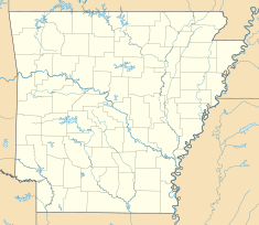
| Location | Arkansas County, Arkansas / Desha County, Arkansas |
| Coordinates | 33°59′20″N 91°18′47″W / 33.98889°N 91.31306°W |
| Purpose | Flood control, power |
| Status | Operational |
| Construction began | 1963 |
| Opening date | 1968 |
| Dam and spillways | |
| Type of dam | Barrage |
| Impounds | Arkansas River |
| Height (foundation) | 52.4 ft (16.0 m) |
| Power station | |
| Name | Electric Cooperatives of Arkansas Hydropower Generating Station |
| Commission date | 1999 |
| Installed capacity | 102.6 megawatts |
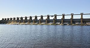
The Wilbur D. Mills Dam is a special kind of dam called a steel dam. It also has a power plant that makes electricity. You can find it on the Arkansas River in Arkansas County and Desha County, which are both in Arkansas, United States.
This dam is an important part of the McClellan–Kerr Arkansas River Navigation System. This system is like a big water highway that helps boats travel on the river. The dam is named after Wilbur D. Mills, who was a politician from Arkansas. He worked in the United States House of Representatives.
Contents
About the Wilbur D. Mills Dam
The Wilbur D. Mills Dam is about 52.4 ft (16.0 m) tall. It is made up of a long dirt wall, called an earthen embankment, which is about 3,773 ft (1,150 m) long. The dam also has a special part called a spillway, which is 5,180 ft (1,580 m) long. The spillway helps control the water flow.
How the Dam Was Built
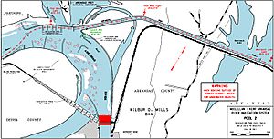
The Arkansas River changes a lot after this dam. It takes a very long, winding path to reach the Mississippi River, which is about 25 mi (40 km) away. In the past, big river boats didn't use this winding part of the river. Instead, they used a different path called the Arkansas Post Canal. This canal was shorter and went straight to the Mississippi River.
When the McClellan–Kerr Arkansas River Navigation System was built between 1963 and 1970, the Arkansas Post Canal was made much better. Because of this, the Wilbur D. Mills Dam was built without a lock. Locks are like water elevators that help boats move between different water levels. Since only small recreational boats use the water below the dam, a lock wasn't needed. The entrance to the Arkansas Post Canal is about 2.5 mi (4.0 km) northwest of the dam.
The dam was first called Dam Number 2. It was built over five years, from 1963 to 1968.
Dam Repairs After a Flood
In 1982, there was a big flood on the Arkansas River. During this flood, 38 barges broke free from their moorings. Barges are large, flat-bottomed boats used for carrying goods. These barges were about 5 mi (8.0 km) to 8 mi (13 km) upstream from the dam.
Fourteen of the barges crashed into the dam. Two of them even went through the dam's open gates! The first repairs cost $141,000. More repairs were needed and started in 1990.
Power from the Dam
A special power plant was added to the dam between 1994 and 1999. This plant uses the force of the water to create electricity. It cost $189 million to build. This power plant can make 102.6 megawatts of electricity. That's enough power for many homes!
Fun at the Dam: Recreation Area
If you visit the Wilbur D. Mills Dam, you can also enjoy the Wilbur D. Mills Campground. It's on the Arkansas County side of the dam. The campground has 21 places where people can set up their tents or park their RVs. There's also a boat launch, so you can put your boat in the water and enjoy the river.


