William Gell facts for kids
Quick facts for kids
Sir
William Gell
|
|
|---|---|

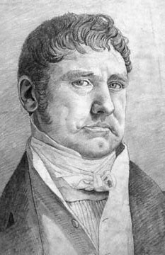
William Gell, by Cornelius Varley, 1816 (National Portrait Gallery).
|
|
| Born | 31 March 1777 Derbyshire, England
|
| Died | 4 February 1836 Naples, Italy
|
| Nationality | English |
| Occupation | Illustrator, archaeologist |
|
Notable work
|
Pompeiana; the Topography, Edifices and Ornaments of Pompeii |
Sir William Gell (born March 29, 1777 – died February 4, 1836) was a British archaeologist and artist. He was known for drawing ancient places. He published drawings of Troy and the area around it in 1804. He also shared drawings from Pompeii, an ancient Roman city. His most famous work is Pompeiana, which came out between 1817 and 1832. This book showed the layout and buildings of Pompeii.
Contents
Early Life and Learning
William Gell was born in a place called Hopton in Derbyshire, England. His father was Philip Gell and his mother was Dorothy Milnes. The Gell family was very old and had a history of serving in the military and government since the year 1209.
William went to Derby School and then to Emmanuel College at Cambridge University. He started there in 1793. He earned his first degree (BA) in 1798 and a master's degree (MA) in 1804. He also became a "fellow" of Emmanuel College, which means he was a senior member of the college.
Exploring Ancient Troy
In 1801, when William Gell was 24, he went on his first important trip to Greece. He traveled around Greece, nearby islands, and the coast of Asia Minor (modern-day Turkey) from 1804 to 1806.
In 1804, he believed he had found the location of the ancient city of Troy. He thought it was at a place called Bournabashi. This spot was about six miles south of where most experts now agree Troy was, which is at Hisarlik. He used ideas from other explorers and his own observations to support his theory.
He published a book about his findings called The Topography of Troy and its vicinity. This book included drawings and descriptions of the area.
The famous poet Lord Byron even mentioned William Gell in his poem 'English Bards'. He wrote:
Of Dardan tours let dilettanti tell
I leave topography to classic Gell.
This means Byron thought Gell was the expert on mapping ancient places.
Later Years and Discoveries
From 1820 until he passed away, William Gell lived in Rome, Italy. He also had a home in Naples, where he welcomed many friends. These friends included famous people like Lady Blessington and Sir Walter Scott.
Even though Sir William had a painful joint condition called gout, he took Sir Walter Scott to Pompeii. He showed Scott around the ancient ruins. After Scott died, Sir William wrote down their conversations from Naples. During this time, he published some of his most important archaeological books, including Pompeiana and The Topography of Troy.
Sir William Gell died in Naples in 1836. He was buried in the English Cemetery, Naples. He left all his personal items to his friend Keppel Craven.
Lasting Impact
Sir William Gell made many detailed drawings of ancient ruins and places. These drawings are now kept in the British Museum. Even though some people thought he was more of a hobbyist than a serious scholar, his books about places became important guides. This was especially true when Greece and Italy were not well-known to English travelers.
He was a member of important groups like the Royal Society and the Society of Antiquaries of London. He was also part of the Institute of France and the Royal Academy in Berlin.
His most famous book, Pompeiana, was published between 1817 and 1832. He worked with J. P. Gandy on the first part of it. Later, he wrote The Topography of Rome and its Vicinity in 1834. He also wrote:
- Topography of Troy and its Vicinity (1804)
- Geography and Antiquities of Ithaca (1807)
- Itinerary of Greece (1810)
- Itinerary of the Morea (1816)
Even though newer books have come out, his works still offer valuable information for studying ancient places. Some modern experts see him, along with his friends Edward Dodwell and Keppel Richard Craven, as the founders of studying the historical layout of the area around Rome. His books and notes were very helpful for later studies by Thomas Ashby in the early 1900s.
Works
- A Tour in the Lakes Made in 1797, [Edited by W. Rollinson, published 1986]
- The Topography of Troy and its vicinity illustrated and explained by drawings and descriptions etc.. London, 1804
- The Geography and Antiquities of Ithaca. London, 1807
- The Itinerary of Greece, with a commentary on Pausanias and Strabo, and an account of the Monuments of Antiquity at present existing in that country, compiled in the years 1801, 2, 5, 6 etc.. London, 1810. [2nd ed. containing a hundred routes in Attica, Boeotia, Phocis, 1827]
- The Itinerary of the Morea, being a description of the Routes of that Peninsula. London, 1817
- Views in Barbary – taken in 1813. London, 1815
- Pompeiana. The Topography of Edifices and Ornaments of Pompeii. 2 vols. London, 1817–8. [New ed. 1824. Further edition by Gell alone incorporating the results of latest excavations. London 1832 and 1852]
- Narrative of a Journey in the Morea. London, 1823
- Le Mura di Roma disegnate sa Sir W. Gell, illustrate con testo e note da A. Nibby. Rome, 1820
- Probestücke von Städtemauern des alten Griechenlands ... Aus dem Englischen übersetzt. Munich, 1831
- The Topography of Rome and its Vicinity with Map. 2 vols. London, 1834. [Rev. and enlarged by Edward Henry Banbury. London 1846]
- Analisi storico-topografico-antiquaria della carta de' dintorni di Roma secondo le osservazione di Sir W. Gell e del professore A. Nibby. Rome 1837 [2nd ed. 1848]
 | Frances Mary Albrier |
 | Whitney Young |
 | Muhammad Ali |

