Winder, Georgia facts for kids
Quick facts for kids
City of Winder
|
|||
|---|---|---|---|
|
City
|
|||

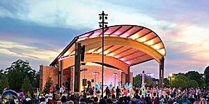
Jug Tavern Park
|
|||
|
|||
| Motto(s):
"City of Opportunity"
|
|||

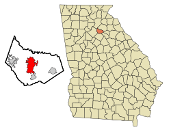
Location in Barrow County and the state of Georgia
|
|||
| Country | United States | ||
| State | Georgia | ||
| County | Barrow | ||
| Area | |||
| • Total | 14.17 sq mi (36.70 km2) | ||
| • Land | 13.69 sq mi (35.44 km2) | ||
| • Water | 0.48 sq mi (1.26 km2) | ||
| Elevation | 988 ft (301 m) | ||
| Population
(2020)
|
|||
| • Total | 18,338 | ||
| • Density | 1,340.01/sq mi (517.36/km2) | ||
| Time zone | UTC-5 (Eastern (EST)) | ||
| • Summer (DST) | UTC-4 (EDT) | ||
| ZIP code |
30680
|
||
| Area code(s) | 470/678/770 | ||
| FIPS code | 13-83420 | ||
| GNIS feature ID | 0325442 | ||
Winder (pronounced WYNE-der) is a city in Georgia, United States. It is the main city, or county seat, of Barrow County. Winder is located east of Atlanta and is part of the larger Atlanta area. In 2020, about 18,338 people lived there.
Contents
History of Winder
The land where Winder is now was first home to the Creek people.
How Winder Got Its Name
The city of Winder was officially created in 1893. It was named after John H. Winder, who helped build railroads. Before it was called Winder, the community had a different name: Jug Tavern.
The First Doctors' Day
An important event in medical history happened in Winder. The very first "Doctors' Day" was celebrated here on March 28, 1933. This day was created to honor doctors for their hard work.
The idea came from Mrs. Eudora Brown Almond. She wanted to pay tribute to doctors, including Dr. Crawford Long. He was a doctor who performed the first surgery using general anesthesia in 1842. The celebration included sending cards to doctors and their families, placing flowers on graves of doctors who had passed away, and a special dinner.
The idea of Doctors' Day grew from Winder. It was adopted by medical groups in Georgia and then across the Southern United States. Now, Doctors' Day is celebrated widely to thank medical professionals.
Geography of Winder
Winder is located in the middle of Barrow County. It is about 20 miles west of Athens and 50 miles northeast of downtown Atlanta.
The city covers a total area of about 14.17 square miles (36.7 square kilometers). Most of this area is land, with a small part being water.
Population and People
Winder has grown a lot over the years. In 1890, only 202 people lived there. By 2020, the population had grown to 18,338.
The city has become more diverse over time. People from many different backgrounds live in Winder, making it a vibrant community.
Arts and Culture
Winder has places where you can learn about history and art.
Historic Places
The Barrow County Courthouse in Winder is a special building. It was built in 1920 and is listed on the National Register of Historic Places. This means it is an important historical site.
Barrow County Museum
The Barrow County Museum is a great place to discover the history of Barrow County. It keeps many old items and stories from the area. The museum is located in the old Barrow County Jail building. It is also home to the Barrow County Historical Society.
Education in Winder
Winder has many schools for students of all ages.
Public Schools
The public schools in Winder are part of the Barrow County School District. This district has many schools, including:
- Eight elementary schools
- Four middle schools
- Two high schools
The district has over 9,362 students and about 610 full-time teachers.
Students in Winder attend different high schools depending on where they live. Some go to Winder-Barrow High School, while others go to Apalachee High School. There are also several elementary and middle schools that serve the Winder area.
The Arts and Innovation Magnet Program is also located in Winder.
Here is a list of schools in the Winder area:
- County Line Elementary School
- Holsenbeck Elementary School
- Kennedy Elementary School
- Winder Elementary School
- Yargo Elementary School
- Arts and Innovation Magnet Program
- Bramlett Elementary School
- Westside Middle School
- Richard B. Russell Middle School
- Haymon-Morris Middle School
- Bear Creek Middle School
- Winder-Barrow High School
- Apalachee High School
- Barrow Arts and Sciences Academy (BASA)
- Sims Academy of Innovation and Technology
Former Schools
- Winder-Barrow Middle School (closed in 2013)
- Snodon Preparatory School (closed in 2014)
Private Schools
- Bethlehem Christian Academy
- B.C.C.A Barrow County Christian Academy
Colleges and Universities
- Lanier Technical College - (Winder-Barrow Campus)
Transportation
Major Roads
Walking and Biking
Currently, there are not many places to walk or bike easily in Winder. However, nearby counties like Clarke, Gwinnett, and Hall have trails that people can use for walking and cycling.
See also
 In Spanish: Winder para niños
 | Precious Adams |
 | Lauren Anderson |
 | Janet Collins |


