
Balmoral (District Electoral Area) facts for kids
Quick facts for kids Balmoral |
|
|---|---|
| Belfast City Council DEA Constituency | |

Balmoral DEA marked on a map of Belfast City Council and its wards
|
|
| Current constituency | |
| Created | 1985 |
| Seats | 5 (1985-1993) 6 (1993–2014) 5 (2014–) |
| Councillors | |

Balmoral (from the Irish: Baile Mhoireil) is a district in Belfast, Northern Ireland. It's the most southern of the ten areas that elect people to the Belfast City Council. This area chooses five members to represent its local community.
Balmoral includes several smaller areas called wards, such as Belvoir, Finaghy, Malone, Musgrave, Windsor, and Upper Malone. Together with the nearby Botanic area, Balmoral makes up a big part of the Belfast South areas for both the Northern Ireland Assembly (where laws are made for Northern Ireland) and the UK Parliament (where laws are made for the whole UK).
The district has clear boundaries: the M1 Motorway is to its west and southwest, the River Lagan is to its east and southeast, and the Malone Road is to its east and northeast. To the north, you'll find important places like Belfast City Hospital, Queen's University Belfast, and Royal Victoria Hospital.
The Lisburn Road is a main road that runs through the middle of Balmoral. The area is also home to several public places, including the King's Hall (a big place for events), Musgrave Park Hospital, Sir Thomas and Lady Dixon Park (a lovely park), and Windsor Park. Windsor Park is especially famous as it's the home stadium for the Northern Ireland national football team. You can also get around Balmoral using the Adelaide, Balmoral, and Finaghy train stations.
History of Balmoral
This area, known as a District Electoral Area (DEA), was first created for local elections in 1985. Back then, it had five wards. Four of these wards came from an older area called Belfast Area C, which Balmoral mostly replaced. The last ward, Blackstaff, came from Belfast Area F.
From the 1993 local elections until the 2011 elections, Balmoral had six wards because the Musgrave ward was added. However, for the 2014 local elections, things changed again. Balmoral lost the Blackstaff and Windsor wards but gained the Belvoir ward. Belvoir used to be part of the Castlereagh Borough Council, which was removed as part of the 2014 Local Government Reform. These changes helped to update how local government works in Northern Ireland.
Local Representatives
People who are elected to represent an area on the council are called councillors. They work to make decisions that affect the local community. Balmoral elects councillors to the Belfast City Council.
Sometimes, councillors are also given special titles. For example, in May 2011, Councillors Tom Ekin, Ruth Patterson, and Bob Stoker were named "Aldermen" by the Belfast City Council. An Alderman is a senior member of the council. Ruth Patterson also served as the "Deputy Lord Mayor" of Belfast from 2011 to 2012, which is a very important role. Later, Mairtin O'Muilleoir became the "Lord Mayor" for 2013-2014, which is the highest position in the city council.
In the 2023 election, Balmoral elected five councillors. The results showed a change from the previous election in 2019. In 2019, the area had two councillors from the DUP, one from SDLP, one from Alliance, and one from Sinn Féin. In 2023, the Alliance Party gained a seat from the DUP, so the representation became two from Alliance, one from DUP, one from SDLP, and one from Sinn Féin. This means the Alliance Party now has more representatives in Balmoral.
Images for kids
-
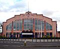
The King's Hall is a multi-purpose venue located in Balmoral.
-
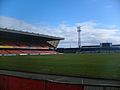
Windsor Park is the home of the Northern Ireland football team.


