Witchcliffe, Western Australia facts for kids
Quick facts for kids WitchcliffeWestern Australia |
|
|---|---|

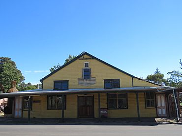
The heritage listed former Darnell's General Store in Witchcliffe in 2021
|
|
| Established | 1926 |
| Postcode(s) | 6286 |
| Elevation | 89 m (292 ft) |
| Area | [convert: needs a number] |
| Location |
|
| LGA(s) | Shire of Augusta-Margaret River |
| State electorate(s) | Warren-Blackwood |
| Federal Division(s) | Forrest |
Witchcliffe is a small town in the South West part of Western Australia. It's located just a few kilometers south of Margaret River, right on the Bussell Highway. The town's name comes from a cave in the area called Witchcliffe Cave. A surveyor first recorded this cave in 1900. It's thought that the Bussell family gave the cave its name. Their property, Wallcliffe, was set up in the area back in the 1850s.
The Story of Witchcliffe
In 1924, the government extended a train line, called the Flinders Bay branch railway, to Witchcliffe. The train stop was first going to be named Narawary. However, a post office had already opened in 1923 with the name Witchcliffe. So, the train stop was officially named Witchcliffe in 1925.
Land lots were measured and sold along the train line in 1924. The official townsite of Witchcliffe was then created in 1926.
Witchcliffe's Timber Industry
The town of Witchcliffe grew because of the timber industry. A large sawmill was built in 1922, just east of town. It was built for a company called W.A. Jarrah Forests Ltd. Later, in 1929, the Adelaide Timber company took over the sawmill.
Witchcliffe's Weather
Witchcliffe has a climate that changes throughout the year. Here's a look at the weather:
| Climate data for Witchcliffe | |||||||||||||
|---|---|---|---|---|---|---|---|---|---|---|---|---|---|
| Month | Jan | Feb | Mar | Apr | May | Jun | Jul | Aug | Sep | Oct | Nov | Dec | Year |
| Record high °C (°F) | 40.6 (105.1) |
39.4 (102.9) |
39.0 (102.2) |
32.6 (90.7) |
27.7 (81.9) |
22.5 (72.5) |
21.2 (70.2) |
22.1 (71.8) |
25.0 (77.0) |
32.4 (90.3) |
36.2 (97.2) |
40.6 (105.1) |
40.6 (105.1) |
| Mean daily maximum °C (°F) | — | 27.3 (81.1) |
25.9 (78.6) |
22.7 (72.9) |
19.9 (67.8) |
17.5 (63.5) |
16.4 (61.5) |
16.7 (62.1) |
17.4 (63.3) |
19.5 (67.1) |
22.8 (73.0) |
24.8 (76.6) |
21.4 (70.5) |
| Mean daily minimum °C (°F) | 13.9 (57.0) |
14.5 (58.1) |
13.0 (55.4) |
11.1 (52.0) |
9.8 (49.6) |
8.8 (47.8) |
8.0 (46.4) |
8.2 (46.8) |
8.8 (47.8) |
9.1 (48.4) |
10.9 (51.6) |
12.4 (54.3) |
10.7 (51.3) |
| Record low °C (°F) | 4.5 (40.1) |
5.9 (42.6) |
3.2 (37.8) |
3.0 (37.4) |
−1.5 (29.3) |
−0.7 (30.7) |
−1.0 (30.2) |
0.5 (32.9) |
1.1 (34.0) |
2.4 (36.3) |
3.4 (38.1) |
4.0 (39.2) |
−1.5 (29.3) |
| Average precipitation mm (inches) | 11.1 (0.44) |
8.2 (0.32) |
22.3 (0.88) |
65.0 (2.56) |
138.7 (5.46) |
177.2 (6.98) |
193.2 (7.61) |
150.2 (5.91) |
116.9 (4.60) |
61.1 (2.41) |
38.2 (1.50) |
15.0 (0.59) |
1,018.7 (40.11) |
| Average precipitation days | 3.8 | 5.1 | 7.3 | 14.1 | 18.6 | 20.9 | 23.4 | 22.4 | 20.3 | 16.6 | 11.0 | 7.3 | 170.8 |
| Average relative humidity (%) | 50 | 48 | 50 | 57 | 62 | 67 | 67 | 65 | 64 | 61 | 55 | 52 | 58 |
 | James Van Der Zee |
 | Alma Thomas |
 | Ellis Wilson |
 | Margaret Taylor-Burroughs |


