
Wolf Run (Sugar Creek tributary) facts for kids
Quick facts for kids Wolf Run |
|
|---|---|


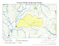
Location of Wolf Run mouth
|
|
| Other name(s) | Tributary to Sugar Creek |
| Country | United States |
| State | Pennsylvania |
| County | Venango |
| Physical characteristics | |
| Main source | West Branch Two Mile Creek divide about 1 mile south of Haslets Corners, Pennsylvania 1,450 ft (440 m) 41°28′54″N 079°49′09″W / 41.48167°N 79.81917°W |
| River mouth | Sugar Creek about 0.25 miles east of McKenzie Corners, Pennsylvania 1,083 ft (330 m) 41°28′18″N 079°52′53″W / 41.47167°N 79.88139°W |
| Length | 4.43 mi (7.13 km) |
| Basin features | |
| Progression | generally west |
| River system | Allegheny River |
| Basin size | 6.02 square miles (15.6 km2) |
| Tributaries |
|
Wolf Run is a small stream, about 4.43 miles (7.13 km) long. It flows into Sugar Creek in Venango County, Pennsylvania. This stream is an important part of the local water system.
Where Wolf Run Flows
Wolf Run begins in Venango County, Pennsylvania. It starts near a place called Haslets Corners. The stream then flows mostly towards the west. It ends when it joins Sugar Creek. This meeting point is close to McKenzie Corners, also in Venango County.
The Wolf Run Area
The area that Wolf Run drains is called its watershed. This watershed covers about 6.02 square miles (15.6 square kilometers). Each year, this area gets about 44.4 inches (113 cm) of rain. The average water temperature in Wolf Run is about 8.11 degrees Celsius (46.6 degrees Fahrenheit). Most of the land in this watershed, about 78%, is covered by forests.
Images for kids
-
The path of Wolf Run
-
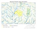
The area drained by Wolf Run
.jpg)
.jpg)
