
Wood River Wetland facts for kids
Quick facts for kids Wood River Wetland |
|
|---|---|

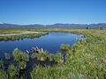
Wood River Marsh at the Wetland
|
|

Wood River Wetland
Location in Oregon
|
|
| Location | Chiloquin, Oregon |
| Coordinates | 42°35′N 121°56′E / 42.58°N 121.93°E |
| Type | Freshwater |
| Primary inflows | Wood River |
| Basin countries | United States |
| Surface area | 3,200 acres (1,300 ha) |
| Max. depth | 2 metres (6 ft 7 in) |
| Surface elevation | 4,180 feet (1,270 m) |
| Settlements | Chiloquin |
The Wood River Wetland is a special natural area in Klamath County, Oregon. It's a large marsh, which is a type of wetland filled with freshwater. Wetlands are super important because they act like natural sponges, cleaning water and providing homes for wildlife. This wetland sits right next to the northern part of Agency Lake.
About the Wood River Wetland
The Wood River Wetland gets its water from the Wood River. This river starts from a big natural spring. This spring is found in the Jackson F. Kimball State Recreation Site. The water for the spring comes from an aquifer. An aquifer is like a huge underground water storage area. This particular aquifer is fed by water from the east side of Crater Lake National Park.
What Lives There?
The wetland is a busy place! It has many different kinds of wetland plants. It's also home to lots of local animals. Many types of waterfowl, like ducks and geese, live here. It's also a stop for birds that are migrating, meaning they fly long distances between their summer and winter homes. This makes the wetland a very important place for wildlife.
How is it Being Helped?
Since the early 1990s, people have been working to restore the Wood River Wetland. The Bureau of Land Management (BLM) is a government group that manages public lands. They have been leading this effort. The goal is to help the Wood River flow naturally again. This helps improve the homes for native fish. It also makes it easier for fish to move through the river.
Images for kids
-
Wood River Marsh at the Wetland
