
Wood River (Oregon) facts for kids
Quick facts for kids Wood River |
|
|---|---|

The Wood River
|
|
| Physical characteristics | |
| Main source | Crater Lake watershed 4,211 ft (1,284 m) |
| River mouth | Agency Lake 4,144 ft (1,263 m) |
| Length | 18 mi (29 km) |
| Basin features | |
| Basin size | 220 sq mi (570 km2) |
The Wood River is a short river located in the southern part of Oregon, a state in the United States. It is an important part of the Klamath Basin water system. The river flows for about 18 miles (29 km) through different types of land. This includes the Fremont-Winema National Forests, land managed by the Bureau of Land Management, and private areas.
The area drained by the Wood River, called its watershed, covers about 220 square miles (570 km2). This land is made up of conifer forests, open fields used for farming, and marshy areas. The river is a home for many different animals. This includes Great Basin redband trout, which are a type of fish that can live in the river all the time or migrate (move) to different places.
Contents
Where Does the Wood River Flow?
The Wood River starts in Klamath County, Oregon. Its main source is a large natural spring found at Jackson F. Kimball State Recreation Site. Scientists believe the underground water that feeds this spring comes from about 20 miles (32 km) away. This water likely originates from the eastern side of Crater Lake National Park.
The Wood River winds its way through pine forests and farm fields for about 18 miles (29 km). Eventually, it flows into Agency Lake.
Annie Creek: A Major Helper
The biggest stream that flows into the Wood River is called Annie Creek. This creek starts inside Crater Lake National Park. It gets its water from the park's snowmelt and from natural underground springs.
After leaving the park, Annie Creek flows through the Fremont-Winema National Forests. It then runs along the western edge of Sun Pass State Forest for about a mile. Next, it crosses private farmland and is joined by Sun Creek. Finally, Annie Creek meets the Wood River about a mile south of Kimball State Recreation Site.
The River's Journey to Agency Lake
From where Annie Creek joins it, the Wood River flows south. It passes through the Fremont-Winema National Forests and private farmlands. Then, Fort Creek adds its water to the river. Below Fort Creek, the river continues through private fields and then spreads out into a wide marsh. Much of this marsh was once natural wetland but is now used as pasture.
Water from the Wood River is moved into a system of canals. These canals are used to water the grazing lands in the valley nearby. Finally, Crooked Creek joins the Wood River about a mile before it empties into Agency Lake. Agency Lake is connected to Upper Klamath Lake.
How Much Water Flows?
On average, the Wood River releases about 319 cubic feet per second (9.0 m3/s) of water where it meets Agency Lake.
The Wood River Watershed
,_drainage_basin_map.png)
The Wood River watershed is the area of land that drains into the river. It covers about 220 square miles (570 km2) of forest land. This area is located in the Cascade Range mountains southeast of Crater Lake and the Wood River Valley.
The land around the river's starting point is mostly forest. It has many ponderosa pine and lodgepole pine trees. You can also find some quaking aspen trees in the open meadow areas.
Annie Creek flows through steep mountain forests. From its start to the edge of Crater Lake National Park, Annie Creek has carved a deep canyon. This canyon is a well-known sight within the park. After leaving the park, Annie Creek flows into flat meadow lands near the western border of Sun Pass State Forest.
Annie Creek also supplies water to several irrigation canals. These include Scott Ditch, Shattuck Ditch, Loosely-Streeter-Cardwell Ditch, and Copeland Lateral Ditch. Any extra water from these canals flows back into Annie Creek and the Wood River. The lower part of the Wood River flows through pasture land and then into a large marsh before reaching Agency Lake.
History of the Area
In 1863, the United States Army built Fort Klamath near the Wood River in southern Oregon. Soldiers built a sawmill on Fort Creek. They used the wood from this mill to construct buildings for officers, soldiers, a guardhouse, a hospital, and stables. North of the fort, the army planted about 3,000 acres (12 km2) of grass. This grass was used to feed their horses and mules. The fort was closed down in 1889. None of the original buildings are still standing today.
Animals and Plants of the Wood River
The Wood River is a great home for many types of fish. It has wild populations of brook, brown, Great Basin redband, and coastal rainbow trout. These fish live throughout the entire river system, from its beginning to Agency Lake. Bull trout are native to upper Sun Creek, which is inside Crater Lake National Park. Great Basin redband trout and coastal rainbow trout are both types of rainbow trout that are native to the Klamath basin. The Oregon Department of Fish and Wildlife considers the redband trout population in the Wood River area to be healthy.
Annie Creek and Sun Creek are very important because water and riparian habitat (the area along the riverbanks) are rare in this region. Both creeks are considered large streams that support fish. This means enough water flow is kept in the creeks to help aquatic life.
.png)
Besides fish, the Wood River valley is home to many ducks, shorebirds, and songbirds that nest there. These include wood ducks, mallards, cinnamon teal, Canada geese, mergansers, American coots, common snipes, mourning doves, killdeer, great egrets, meadowlarks, and yellow warblers. You can also find bald eagles, ospreys, and northern harriers nesting in the area.
The river also provides a home for other animals like beavers, river otters, and muskrats. Many land animals live in the Wood River area too. These include raccoons, gray squirrels, martens, mink, red fox, gray fox, mule deer, bobcats, and black bears. You will also see many beef cattle in the Wood River Valley.
In September 1992, the U.S. Congress gave money to the Bureau of Land Management. This money was used to buy about 3,200 acres (13 km2) of natural wetland. This wetland is located at the northern end of Agency Lake, where the Wood River flows in. This wetland area had been turned into pasture land in the 1950s and 1960s. The land purchase was finished in 1994.
Since buying the Wood River property, the Bureau of Land Management has successfully brought the wetland area back to its natural state. They also restored the Wood River channel. The channel restoration project was completed in 2001. The new river channel now winds through the marsh, making the Wood River over half a mile longer. This project has made the water cleaner and created better homes for fish, birds, and other wildlife.
Fun Things to Do at Wood River

There are several places along the Wood River where you can have fun.
Jackson F. Kimball State Recreation Site
This park has a picnic area for day use and ten campsites. You can enjoy activities like fishing, canoeing, and kayaking. A short path connects the main campground to the spring where the Wood River begins. The park is located just off Oregon Route 232. It is about 20 miles (32 km) southeast of Crater Lake National Park and 40 miles (64 km) northwest of Klamath Falls, Oregon.
Fremont-Winema National Forest Site
The Fremont-Winema National Forest has a day-use area along the Wood River. This spot gives you access to hiking trails and places to fish from the shore. It also has picnic tables and restrooms. However, you need to bring your own drinking water. The site is about 33-mile (53 km) north of Klamath Falls on Sun Pass Road. It is a mile off Highway 62, also known as Crater Lake Highway.
Wood River Wetland Area
At the mouth of the Wood River, the Bureau of Land Management manages the 3,200-acre (13 km2) Wood River Wetland area. This wetland is open all year for day activities. You can go fishing, canoeing, kayaking, and watch birds and other wildlife. During hunting season, you can also go waterfowl hunting.
The wetland has a paved parking area, restrooms, picnic spots, nature trails, and a place to launch canoes. There are also signs that explain things about the area. However, there is no drinking water available. You cannot drive motorized vehicles beyond the parking area. During hunting season, the Wood River Wetland opens two hours before sunrise and closes a half-hour after sunset. The entrance to the Wood River Wetland is just off Modoc Point Road, about 26-mile (42 km) north of Klamath Falls.
Fishing in the Wood River
The Wood River is a great place for fishing. You can fish from the shore or use a canoe or kayak. You can find brook, brown, Great Basin redband, and coastal rainbow trout in the Wood River and its smaller streams.
Images for kids
-
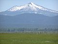
Wood River valley
-
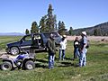
Site monitoring team
-
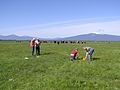
Vegetation survey
-
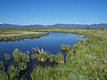
Healthy channel


