Woomargama facts for kids
Quick facts for kids WoomargamaNew South Wales |
|
|---|---|

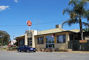
Hotel/Motel
|
|
| Population | 251 (2006 census) |
| Postcode(s) | 2644 |
| Elevation | 407 m (1,335 ft) |
| Location | |
| LGA(s) | Greater Hume Shire Council |
| County | Goulburn |
| State electorate(s) | Albury |
| Federal Division(s) | Farrer |
Woomargama (pronounced woo-MAR-gam-uh) is a small place in southwestern New South Wales, Australia. It is located in an area called the South West Slopes. This area is at the bottom of the Great Dividing Range mountains.
Woomargama is part of the Greater Hume Shire local government area. It is about 508 kilometres (316 mi) southwest of Sydney, which is the capital city of New South Wales. It is also about 48 kilometres (30 mi) northeast of Albury, a larger city nearby. In 2006, Woomargama had a population of 251 people.
What's in Woomargama?
This small village has a few important places. You can find a hotel and motel there. The local post office is in an old school building, which is quite historic.
There is also a community hall for events. The village has a fire station to keep everyone safe. For fun, there are tennis courts and a park with a BBQ area. The park also has public restrooms.
Woomargama is a great spot to visit if you want to explore nature. It is close to Woomargama National Park. You can also easily get to the upper parts of the Murray River from here.
History of the Post Office
The Woomargama Post Office has been around for a long time. It first opened its doors on August 1, 1875.
Woomargama Bypass Road
A special road called the Woomargama bypass opened in November 2011. A bypass is a road that goes around a town instead of through it. This helps traffic move more smoothly.
The Woomargama bypass is located to the west of the town. It connects to the main highways that go north and south. This means cars and trucks can avoid driving right through the village.


