Wunsiedel (district) facts for kids
Quick facts for kids
Wunsiedel
|
||
|---|---|---|
|
||
| Country | ||
| State | Bavaria | |
| Adm. region | Upper Franconia | |
| Region | Oberfranken-Ost | |
| Capital | Wunsiedel | |
| Area | ||
| • Total | 606.40 km2 (234.13 sq mi) | |
| Population
(2003)
|
||
| • Total | 83,899 | |
| • Density | 138.3559/km2 (358.340/sq mi) | |
| Time zone | UTC+1 (CET) | |
| • Summer (DST) | UTC+2 (CEST) | |
| Vehicle registration | WUN | |
| Website | landkreis-wunsiedel.de | |
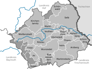
Wunsiedel (which in German is called Landkreis Wunsiedel i. Fichtelgebirge) is a special area in Bavaria, Germany. It's known as a "Landkreis," which means a district.
This district is located in the beautiful Fichtelgebirge mountains. The tallest point in the area is Schneeberg mountain, which stands 1051 meters high. A river called Ohře (also known as Eger) also begins its journey right here in the Wunsiedel district.
Cities and Towns in Wunsiedel
The Wunsiedel district is home to several interesting cities and smaller towns. Some of these places work together in groups called "Verwaltungsgemeinschaften." This means they share some administrative tasks to make things easier for everyone.
Here are the main cities and towns you can find in the Wunsiedel district:
Cities
- Arzberg
- Hohenberg an der Eger¹
- Kirchenlamitz
- Marktleuthen
- Marktredwitz
- Schönwald
- Selb
- Weißenstadt
- Wunsiedel
Villages and Municipalities
- Bad Alexandersbad¹
- Höchstädt im Fichtelgebirge¹
- Nagel¹
- Röslau
- Schirnding¹
- Thiersheim¹
- Thierstein¹
- Tröstau¹
¹ These places are part of a "Verwaltungsgemeinschaft," which is a group of towns that share some local government services.
See also
 You can also read about the Wunsiedel district in Spanish: Distrito de Wunsiedel para niños
 | Chris Smalls |
 | Fred Hampton |
 | Ralph Abernathy |


