Yarrowsburg, Maryland facts for kids
Quick facts for kids
Yarrowsburg, Maryland
|
|
|---|---|
| Country | United States |
| State | Maryland |
| County | Washington |
| Area | |
| • Total | 0.23 sq mi (0.59 km2) |
| • Land | 0.23 sq mi (0.59 km2) |
| • Water | 0.00 sq mi (0.00 km2) |
| Elevation | 643 ft (196 m) |
| Population
(2020)
|
|
| • Total | 112 |
| • Density | 493.39/sq mi (190.37/km2) |
| Time zone | UTC−5 (Eastern (EST)) |
| • Summer (DST) | UTC−4 (EDT) |
| ZIP code |
21758
|
| Area code(s) | 301, 240 |
| GNIS feature ID | 2583707 |
Yarrowsburg is a small place in Washington County, Maryland, in the United States. It's called an unincorporated community, which means it doesn't have its own local government like a city or town. It's also a census-designated place, meaning the government counts its population for official records. In 2010, about 133 people lived there.
Contents
History of Yarrowsburg
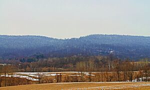
Yarrowsburg is located at the base of Elk Ridge mountain. It sits on the west side of Pleasant Valley. The community stretches along Reed, Kaetzel, and Yarrowsburg roads in the southeastern part of Washington County.
Early Land Use
For a long time, until the late 1800s, Elk Ridge mountain was owned by the Antietam Iron Works. This company used the trees from the forest to make charcoal. Charcoal was a very important fuel for their iron furnace and forges.
After the trees were cut down, and especially after the iron works went out of business in the 1850s, the mountain land was sold off. Many properties in Yarrowsburg today were once part of the iron works' land.
How Yarrowsburg Got Its Name
The village is named after Aquila and Polly Yarrow. They were free African Americans who bought a small log house and some land in 1825. Their home was at the corner of Yarrowsburg and Reed roads.
The Yarrows were one of several free Black families living in the area at that time. It's believed that Aquila worked as a collier, someone who makes charcoal, for the iron works. Aquila passed away in 1832, but Polly lived in the village named for her until 1885.
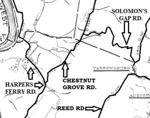
Solomon's Gap
Yarrowsburg was also the site of the only historical path through Elk Ridge mountain. This path was called Solomon's Gap. It was very steep and rocky. To get around Elk Ridge otherwise, you had to go all the way around its north or south ends.
The road through Solomon's Gap was no longer used as a main road in the early 1900s. It is not a through road today. Solomon's Gap was important in the strategies of battles during the American Civil War in that area. Today, Yarrowsburg is a quiet rural village with single-family homes.
Geography of Yarrowsburg
According to the U.S. Census Bureau, Yarrowsburg covers an area of about 0.227 square miles (0.59 square kilometers). All of this area is land.
Population Information
| Historical population | |||
|---|---|---|---|
| Census | Pop. | %± | |
| 2020 | 112 | — | |
| U.S. Decennial Census | |||
The population of Yarrowsburg was 112 people in 2020. This information comes from the U.S. Decennial Census, which counts the population every ten years.
See also
 In Spanish: Yarrowsburg para niños


