Yellow River (Pensacola Bay) facts for kids
Quick facts for kids Yellow River |
|
|---|---|

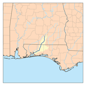
Map of the Yellow River
|
|
| Other name(s) | Chester River |
| Country | United States |
| State | Alabama and Florida |
| Physical characteristics | |
| Main source | Covington County, Alabama 31°27′24″N 86°20′05″W / 31.45655°N 86.33467°W |
| River mouth | Santa Rosa County, Florida 30°33′27″N 86°59′43″W / 30.55741°N 86.99524°W |
| Length | 118 miles (190 km) |
The Yellow River is a cool river in the southern United States. It flows for about 118 miles (190 km). This river travels through two states: Alabama and Florida.
Long ago, people also called it the Chester River or the Middle River. The Yellow River ends its journey by flowing into Blackwater Bay. This bay is a part of the bigger Pensacola Bay.
Journey of the Yellow River
The Yellow River starts its path in Covington County, Alabama. From there, it winds its way south. It crosses the border into Florida.
From Source to Sea
As the river moves through Florida, it passes through Okaloosa County, Florida and Santa Rosa County, Florida. Finally, it reaches Blackwater Bay. This bay then connects to Pensacola Bay, which leads to the Gulf of Mexico. So, the river's water eventually reaches the ocean!
Fun on the River
A big part of the Yellow River is great for outdoor fun! About 54 miles (87 km) of the river are set aside for a special trail. This is called the Yellow River Paddling Trail.
What is a Paddling Trail?
A paddling trail is a marked path on a river. It is made for people who love to paddle. You can use canoes, kayaks, or stand-up paddleboards here. It is a fun way to explore nature.
The Florida Department of Environmental Protection helps manage this trail. They make sure it stays clean and safe for everyone. It's a perfect spot for a family adventure!
 | DeHart Hubbard |
 | Wilma Rudolph |
 | Jesse Owens |
 | Jackie Joyner-Kersee |
 | Major Taylor |

