Yengarie, Queensland facts for kids
Quick facts for kids YengarieQueensland |
|||||||||||||||
|---|---|---|---|---|---|---|---|---|---|---|---|---|---|---|---|

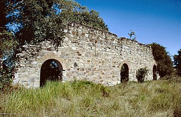
Yengarie Sugar Refinery ruins, 2002
|
|||||||||||||||
| Population | 615 (2021 census) | ||||||||||||||
| • Density | 22.61/km2 (58.6/sq mi) | ||||||||||||||
| Postcode(s) | 4650 | ||||||||||||||
| Area | 27.2 km2 (10.5 sq mi) | ||||||||||||||
| Time zone | AEST (UTC+10:00) | ||||||||||||||
| LGA(s) | Fraser Coast Region | ||||||||||||||
| State electorate(s) | Maryborough | ||||||||||||||
| Federal Division(s) | Wide Bay | ||||||||||||||
|
|||||||||||||||
Yengarie is a small countryside area in Queensland, Australia. It's part of the Fraser Coast Region. In 2021, about 615 people lived here. It's known as a "locality," which is like a small district or neighborhood in Australia.
Contents
A Look Back at Yengarie's History
Yengarie has an interesting past! A school first opened here on March 30, 1868. At first, the Queensland Government helped pay for it, but didn't run it directly.
The Yengarie State School
On July 14, 1873, the school officially became the Yengarie State School. This meant the government took over running it. By 1873, the school had 89 students. A new building was being built because the old one was "dilapidated" (very old and falling apart) and too crowded. The school stayed open for many years before closing in 1963. You can still find where it used to be at 340 Old Mill Road.
Important Historical Places
Yengarie is home to some special places that are listed for their historical importance. These are called "heritage-listed" sites. They help us remember the past and how people lived and worked long ago.
Sugar Mill Ruins
Two of these important sites are related to sugar production:
- The Central Sugar Mill Ruins on Old Mill Road.
- The Yengarie Sugar Refinery Ruins also on Old Mill Road.
These ruins are like giant clues from the past, showing where sugar was once processed in the area.
 | Isaac Myers |
 | D. Hamilton Jackson |
 | A. Philip Randolph |


