Tinana, Queensland facts for kids
Quick facts for kids TinanaQueensland |
|||||||||||||||
|---|---|---|---|---|---|---|---|---|---|---|---|---|---|---|---|

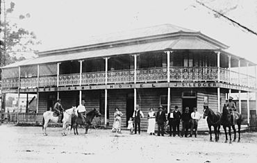
Diggers Arms Hotel
|
|||||||||||||||
| Postcode(s) | 4650 | ||||||||||||||
| Elevation | 10–30 m (33–98 ft) | ||||||||||||||
| Area | 37.3 km2 (14.4 sq mi) | ||||||||||||||
| Time zone | AEST (UTC+10:00) | ||||||||||||||
| Location |
|
||||||||||||||
| LGA(s) | Fraser Coast Region | ||||||||||||||
| State electorate(s) | Maryborough | ||||||||||||||
| Federal Division(s) | Wide Bay | ||||||||||||||
|
|||||||||||||||
Tinana is a small town in Queensland, Australia. It is part of the Fraser Coast Region. In 2021, about 5,872 people lived here. Tinana is a mix of homes and open land.
Contents
Where is Tinana?
Tinana is surrounded by water! The Mary River is on its west, north, and east sides. Tinana Creek forms its south-east border.
Major roads run through Tinana. The Bruce Highway comes from the south and goes around the town. It then leaves to the north, crossing the Mary River on the Henry Palmer Bridge. Another road, Gympie Road, goes right through Tinana. It crosses the Lamington Bridge to reach the centre of Maryborough.
Even though Tinana was once a separate town, the Lamington Bridge made it feel like a part of Maryborough. Most of the land is used for homes. Other areas are used for growing sugarcane and for animals to graze.
A Look Back in Time
The name Tinana comes from Tinana Creek. A surveyor named William Labatt named the creek in 1852. It is thought he named it after Ihikiera Te Tinana. This was a Māori chief known to botanist John Carne Bidwill.
Tinana Creek Provisional School opened in 1871. It closed and reopened a few times before closing for good in 1878.
Tinana State School opened its doors on May 31, 1875.
A church called Holy Trinity Anglican church opened around 1883. It closed about 1918.
The Tinana Congregational Church started on August 30, 1908. Later, in 1932, the Baptist Church took over its services. By 1937, the Baptist Church officially bought the building. This church was located on the corner of Teddington Road and Gympie Road. It is no longer there today.
On Anzac Day in 2015, a special war memorial was revealed at Tinana State School. This was part of the World War I centenary events. The memorial remembers students from the school who served in World War I.
How Many People Live Here?
The number of people living in Tinana has grown over the years:
- In 2011, about 4,877 people lived in Tinana.
- In 2016, the population grew to 5,476 people.
- By 2021, there were 5,872 people living in Tinana.
Important Historical Sites
Tinana has some places that are important to its history:
- The old Pacific Islander Hospital and Cemetery site: This is at the corner of Bluebell Road East and Gernich Road.
- Commissioner Bidwill's Grave: You can find this grave on Cran Road.
Schools and Learning
Tinana State School is a government primary school. It teaches students from Prep to Year 6. Boys and girls attend this school, which is located at 239 Gympie Road. The school also has a special education program. In 2018, there were 498 students enrolled.
There are no high schools in Tinana itself. The closest government high school is Maryborough State High School. It is in Maryborough, which is just to the north-east.
Things to Do and Places to Go
The Tinana branch of the Queensland Country Women's Association (CWA) meets at their hall. This hall is located at 56 Gympie Road.
Tinana also has several parks where you can relax and play:
- Fauna Reserve
- Jack Mason Park
- Leslie Drive Park
- O'Connor Road Park
- Pioneer Country Park
- Schultz Park
- Woocoo Park
Sports and Fun
If you like racing, you might enjoy Maryborough Speedway. It is off Gympie Road and hosts car races. It also has a track for motorcycle speedway. In 2016, this track hosted the Queensland Solo Championship.
Famous People from Tinana
One well-known person who lived in Tinana was John Carne Bidwill. He was a famous botanist, someone who studies plants.
 | May Edward Chinn |
 | Rebecca Cole |
 | Alexa Canady |
 | Dorothy Lavinia Brown |


