Yontocket, California facts for kids
Quick facts for kids
Yontocket
yan’-daa-k’vt
Burnt Ranch
|
|
|---|---|
 |
|
| Country | United States |
| State | California |
| County | Del Norte County |
| Elevation | 30 ft (9 m) |
Yontocket (in the Tolowa language: Yan’-daa-k’vt) is a small community in Del Norte County, California. It is not officially part of a city or town. Yontocket is located about 3 miles (5 km) west-southwest of Smith River. It sits at an elevation of 26 feet (8 meters) next to the Yontocket Slough.
Yontocket Historic District: A Special Place
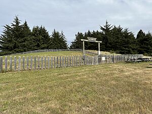
A long time ago, a Tolowa village called Hawunkwut was located in the sand dunes near the Yontocket Slough. Today, this area is known as the Yontocket Historic District. It is an important archeological site, which means it's a place where scientists study old human history.
This site was added to the National Register of Historic Places in 1973. This list includes places that are important to the history of the United States. The district remembers a sad event from 1853. During this time, many Tolowa people were harmed by white settlers. After this event, the village was burned down. Because of this, the area became known as Burnt Ranch. This name is also used for another town in nearby Trinity County, so it can be a bit confusing!
Yontocket Slough: A Changing Waterway
The Yontocket Slough is a narrow channel of water. It used to be the main path for the Smith River about 900 years ago. But over time, the river changed its course.
In 1856, maps showed the slough, then called "Ottawa Slough," connected to the Smith River. Water from Tryon Creek also flowed into Lake Earl. However, moving sand dunes eventually blocked these connections. By 1942, the slough was mostly cut off from the ocean's tides. Other small ponds nearby might be old parts of the river channel.
Before Pala Road was built in 1942, fish like salmon could swim through the slough. This waterway was about 3.5 miles (5.6 km) long. It helped fish travel between the river and their spawning grounds upstream. Since the 1850s, the slough has filled with about 16 inches (41 cm) of silt, which is like fine mud. Now, the slough is mostly separate from the river. It only connects during very high water. Rainwater and runoff feed the slough. Pala Road often floods in winter and spring.
Fish and Wildlife in Yontocket Slough
In 1881, people said the Yontocket Slough was "literally alive with salmon". This was true even after years of fishing for money. In 1861, a fish processing factory and 400 barrels of salmon were washed away by a huge flood.
However, too much fishing, over 50 tons (45,000 kg) per year, caused the fish numbers to drop. Commercial fishing was stopped in the 1930s. Another big flood in 1964 added a lot of grey silt to the slough. This made it shallower and changed the plants, making it harder for fish to live there.
In 1985, the silt was removed by dredging. By 2002, cows were kept out of the slough. After these changes, adult coastal cutthroat trout were found living there. By 2007, groups like the California Conservation Corps planted many trees. They planted over 1,000 Sitka spruce and red alders. They also planted 500 willow sprigs and put up 3,000 feet (914 meters) of fences.
The lower 2,500 feet (762 meters) of the slough were bought by the California Department of Parks and Recreation in the 1970s. Cattle stopped grazing there until the 1990s. Then, Aleutian geese used the short grass for food.
Other native animals seen at the slough include the northern red-legged frog, great egret, and black-crowned night heron. A type of butterfly, the Yontocket satyr ringlet butterfly, was named after Yontocket. This is where the first one was found.
Plants Around Yontocket Slough
An invasive plant called reed canary grass grows all around the slough. It can float in the water in big mats. However, it usually doesn't grow in water deeper than 4.8 feet (1.5 meters). In deeper areas, native yellow pond-lily grows. If the canary grass is flooded by 24 inches (61 cm) during its growing season in June, it stops growing. The wet areas around the slough have patches of Sitka spruce trees and willows.
Public Access and Activities
The Yontocket Slough and the nearby Tolowa Dunes State Park are open to the public. People can go hiking, watch wildlife, and hunt during certain seasons. It's also a great place to enjoy the coast.
Climate in Yontocket
Yontocket has warm, dry summers. The average monthly temperatures do not go above 71.6°F (22°C). According to the Köppen Climate Classification system, Yontocket has a warm-summer Mediterranean climate. This type of climate is often shown as "Csb" on climate maps.
 | Mary Eliza Mahoney |
 | Susie King Taylor |
 | Ida Gray |
 | Eliza Ann Grier |


