Zacatelco facts for kids
Quick facts for kids
Zacatelco, Tlaxcala
|
||
|---|---|---|
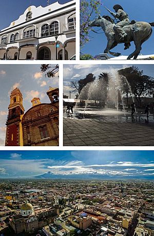
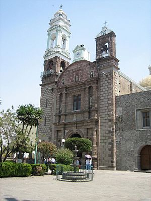
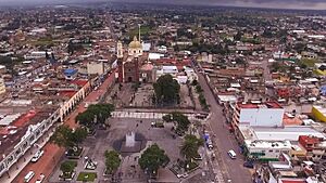
From top to bottom left to right: City hall, Domingo Arenas monument, St. Agnes Parish, Main square, Overview of Zacatelco.
|
||
|
||
| Nickname(s): | ||
| Country | ||
| State | ||
| Municipality | Zacatelco | |
| Foundation | 1 December 1529 | |
| Founded by | Agustín de Castañeda | |
| Area | ||
| • City | 31.38 km2 (12.12 sq mi) | |
| Elevation | 2,210 m (7,257 ft) | |
| Population
(2010)
|
||
| • City | 38,466 | |
| • Estimate
(2015)
|
42,150 | |
| • Metro | 3,010,560 | |
| • Demonym | Zacatelquense | |
| Time zone | UTC-6 (Central) | |
| Area code(s) | 246 | |
| HDI (2020) | ||
| Metropolitan area | Metropolitan area of Puebla | |
Zacatelco is a city in the south of the Mexican state of Tlaxcala. It is also the main town of the Zacatelco municipality. In 2010, about 38,466 people lived here. This makes it the sixth largest city in Tlaxcala. It is also part of the Metropolitan area of Puebla.
The city was founded on December 1, 1529, by Agustín de Castañeda. In 1723, Zacatelco became very important. It formed its own "republic" by joining several nearby towns. These towns used to depend on Tepeyanco.
Zacatelco is known as the "Heart of the South." This name came from a battle cry during the Mexican Revolution. Important figures like the Arenas brothers, who were revolutionaries, came from here. Domingo Arenas led the first land committee in Mexico in 1915.
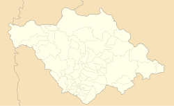
Zacatelco is located in the southern part of the Tlaxcala valley. It is right on the border with the state of Puebla. The city is very high up, at 2,210 meters (7,257 feet) above sea level. This makes it one of the highest cities in Mexico. It is close to other major cities. It's only about 11.9 km from Tlaxcala City, the state capital. It's also 27.1 km from Puebla City and 121.8 km from Mexico City.
Contents
History
Early Settlements
The first signs of people living in Zacatelco date back a very long time. Around 1200 to 800 BC, people from the Tlatempa culture lived here. They built scattered villages and a larger town. There was even a tall building near what is now Tepeyanco.
Later, between 800 and 350 BC, the Texoloc culture grew. Zacatelco was a large town or city next to Cholula. During the Tezoquipan phase, Zacatelco was still a town near Cholula. It also had connections with other villages nearby.
Most historians say that Zacatelco was part of the Ocotelulco lordship. This was one of the four main areas that made up the Republic of Tlaxcala. This was true until the Spanish arrived in Tlaxcala.
Modern Times
In 1945, a new law made Zacatelco an official "free municipality." This meant it could govern itself. Zacatelco was one of 42 such municipalities in Tlaxcala.
The city has made good progress in education and culture. In March 1955, the first high school opened. It was called "Secondary Teaching Number 19 Mariano Matamoros."
Many public spaces have also been built. The municipal park opened in 1967. In 1970, a new municipal market building was opened. A school of Sciences and Humanities (a type of high school) opened in 1972. In 1980, the Zacatelco resort opened, offering a place for people to relax and have fun.
Geography
Where Zacatelco Is Located
Zacatelco is found in the Mexican plateau. It sits at 2,210 meters (7,257 feet) above sea level. You can find it on a map at 19 degrees 13 minutes north latitude and 98 degrees 14 minutes west longitude.
The town is in the southern part of the state. It's in an area called the Poblano-Tlaxcala Valley. To the north, Zacatelco borders San Lorenzo Axocomanitla and Tepeyanco. To the south, it borders the state of Puebla. The east side borders Santa Catarina Ayometla, Santa Cruz Xicohtzinco, and Quilehtla. To the west, it borders Tetlatlahuca and Natívitas. Zacatelco is also part of the Metropolitan area of Puebla.
Places to Visit
Zacatelco is on a special tourist route called "Cacaxtla Xochitécatl." This route leads to the amazing Cacaxtla-Xochitécatl archaeological site. This site is one of the most interesting places to visit nearby.
The city is located about 12 km from Tlaxcala City. You can get there by taking Highway 119 from Puebla to Tlaxcala.
When you visit Zacatelco, you should see the Parish of Santa Ines. This church has a beautiful, huge altarpiece. It is made entirely of wood. Zacatelco offers many interesting places for visitors to enjoy. The main tourist spot is the Zacatelco Resort.
Domingo Arenas Monument
This monument honors Domingo Arenas, a famous revolutionary leader. He sits proudly on his horse in Zacatelco's Central Park. Locals often call it "the horse."
Domingo Arenas was born in Tlaxcala on August 4, 1888. He worked as a shepherd and in factories. When the fight against Porfirio Díaz began, he joined the Maderista forces. His brother, Cirilo Pérez Arenas, was also a very important revolutionary in Tlaxcala.
Parish of Santa Ines
This church was built in the second half of the 1700s. It replaced an older church from the 1500s. The front of the church is in the Baroque style. It has decorative pillars and images of Roman martyrs.
Inside, the church has amazing architecture. It features fluted pillars and beautiful roofs. The dome looks a bit like the one in Puebla Cathedral. The main altar has a large altarpiece. It combines different types of columns and carvings.
This altarpiece is special because of its curved sections. It shows paintings of archangels and other figures. At the very top, there is a carving of Saint Michael. The church also has a holy water font carved from basalt in the early 1600s. It has symbols of the Franciscans carved into its sides.
Water Resources
Zacatelco has several water sources. There is a stream that flows all the time. There are also four other streams that only flow when it rains. The municipality has a small dam, water wells, and springs at the resort. The Zahuapan and Atoyac rivers also provide water to the area.
Climate
The climate in Zacatelco is generally mild and humid. Most of the rain falls from June to September. The hottest months are from March to June. The wind usually blows from north to south.
The average lowest temperature is about 8.2°C (46.8°F). The average highest temperature is about 26.2°C (79.2°F). The city gets about 1048.9 mm (41.3 inches) of rain each year.
| Climate data for Zacatelco (1951–2010) | |||||||||||||
|---|---|---|---|---|---|---|---|---|---|---|---|---|---|
| Month | Jan | Feb | Mar | Apr | May | Jun | Jul | Aug | Sep | Oct | Nov | Dec | Year |
| Record high °C (°F) | 28.0 (82.4) |
31.5 (88.7) |
32.0 (89.6) |
35.5 (95.9) |
36.0 (96.8) |
35.0 (95.0) |
32.0 (89.6) |
30.0 (86.0) |
31.0 (87.8) |
32.0 (89.6) |
34.0 (93.2) |
29.5 (85.1) |
36.0 (96.8) |
| Mean daily maximum °C (°F) | 22.6 (72.7) |
24.5 (76.1) |
26.4 (79.5) |
28.2 (82.8) |
28.2 (82.8) |
26.1 (79.0) |
25.4 (77.7) |
25.3 (77.5) |
25.0 (77.0) |
24.7 (76.5) |
24.5 (76.1) |
22.6 (72.7) |
25.3 (77.5) |
| Daily mean °C (°F) | 13.1 (55.6) |
14.6 (58.3) |
16.3 (61.3) |
17.9 (64.2) |
18.4 (65.1) |
17.9 (64.2) |
17.2 (63.0) |
17.2 (63.0) |
17.3 (63.1) |
16.4 (61.5) |
15.4 (59.7) |
13.6 (56.5) |
16.3 (61.3) |
| Mean daily minimum °C (°F) | 3.6 (38.5) |
4.8 (40.6) |
6.2 (43.2) |
7.7 (45.9) |
8.7 (47.7) |
9.7 (49.5) |
9.0 (48.2) |
9.0 (48.2) |
9.4 (48.9) |
8.1 (46.6) |
6.3 (43.3) |
4.5 (40.1) |
7.3 (45.1) |
| Record low °C (°F) | −3.5 (25.7) |
0.0 (32.0) |
0.0 (32.0) |
0.0 (32.0) |
0.0 (32.0) |
0.1 (32.2) |
0.0 (32.0) |
2.8 (37.0) |
4.0 (39.2) |
0.0 (32.0) |
−1.0 (30.2) |
−2.0 (28.4) |
−3.5 (25.7) |
| Average precipitation mm (inches) | 8.3 (0.33) |
8.0 (0.31) |
9.9 (0.39) |
31.6 (1.24) |
72.8 (2.87) |
163.0 (6.42) |
161.5 (6.36) |
174.2 (6.86) |
155.2 (6.11) |
65.1 (2.56) |
14.6 (0.57) |
7.1 (0.28) |
871.3 (34.30) |
| Average precipitation days (≥ 0.1 mm) | 1.3 | 0.9 | 1.6 | 4.9 | 9.6 | 15.9 | 15.6 | 16.6 | 15.6 | 7.8 | 1.6 | 0.8 | 92.2 |
| Source: Servicio Meteorologico Nacional | |||||||||||||
Culture
Annual Fair
The Zacatelco Fair is a mix of faith, tradition, and culture. It celebrates the Virgin Santa Ines, who is the patron saint of Zacatelco. The fair happens every year on January 21.
During this festival, there are many fun activities. You can enjoy art, cultural shows, sports, and religious events. It's a big community celebration.
It's a tradition for most people in Zacatelco to invite guests to their homes during the fair. They offer a special meal, usually rice, mole poblano, and sometimes barbecue. If you are invited, it's a nice idea to bring a gift. Fruits or bread are common gifts.
The Dance of the Chivarrudos
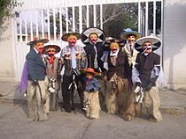
The "Dance of the Chivarrudos" remembers the cowboys and goat herders from the late 1800s and early 1900s. These workers took care of cattle ranches in Tlaxcala. This dance is performed in several towns in the south of the state, including Zacatelco. It has been around for over a hundred years.
The name "CHIVARRUDOS" comes from the special chaps they wear. These chaps are made from goat skins with hair. They make a unique smell when the dancers move. The dancers dress up as cowboys, herders, and farm workers.
They wear dark pants with goat-skin chaps over them. They also wear a white shirt, black jacket, and a red bandana around their neck. Their most striking feature is a red cow mask with big eyebrows and a mustache. The mask has small holes for eyes. They also wear black boots, a wide-brimmed hat, and ride a small wooden horse.
The dance is a funny imitation of the cattle drovers from long ago. A performer plays a Teponaztli (a type of drum) with two sticks. The drum's rhythm sounds like a horse trotting. This rhythm guides the dancers.
Food
Cacao Drink
One of Zacatelco's special traditional drinks is the cacao drink. People also call it "Water Canyon." This unique drink has been named an "Intangible Cultural Heritage" by the state government. This means it's a very important part of their culture.
It is usually served in red bowls that have special designs on them.
Sister cities
See also
 In Spanish: Zacatelco para niños


