
Écrammeville facts for kids
Quick facts for kids
Écrammeville
|
|
|---|---|
|
Part of Formigny La Bataille
|
|

Town hall
|
|

Écrammeville
Location in France

Écrammeville
Location in Normandy
|
|
| Country | France |
| Region | Normandy |
| Department | Calvados |
| Arrondissement | Bayeux |
| Canton | Trévières |
| Commune | Formigny La Bataille |
| Area
1
|
6.84 km2 (2.64 sq mi) |
| Population
(2019)
|
208 |
| • Density | 30.41/km2 (78.76/sq mi) |
| Time zone | UTC+01:00 (CET) |
| • Summer (DST) | UTC+02:00 (CEST) |
| Postal code |
14710
|
| Elevation | 0–48 m (0–157 ft) (avg. 23 m or 75 ft) |
| 1 French Land Register data, which excludes lakes, ponds, glaciers > 1 km2 (0.386 sq mi or 247 acres) and river estuaries. | |
Écrammeville was a small town, also known as a 'commune', located in the Calvados area of Normandy. This region is in northwestern France. Think of a commune like a local community or a small town with its own local government.
On January 1, 2017, Écrammeville joined with another town. It became part of a new, larger commune called Formigny La Bataille. This means Écrammeville is no longer a separate commune on its own.
Population Over Time
The number of people living in Écrammeville changed over the years. Here's a look at how its population grew or shrank:
| Historical population | ||
|---|---|---|
| Year | Pop. | ±% |
| 1962 | 220 | — |
| 1968 | 209 | −5.0% |
| 1975 | 160 | −23.4% |
| 1982 | 161 | +0.6% |
| 1990 | 160 | −0.6% |
| 1999 | 165 | +3.1% |
| 2008 | 198 | +20.0% |
Images for kids
-
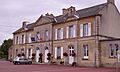
The town hall of Écrammeville. This building was important for local government.
-

A friendly robot.

See also
 In Spanish: Écrammeville para niños

All content from Kiddle encyclopedia articles (including the article images and facts) can be freely used under Attribution-ShareAlike license, unless stated otherwise. Cite this article:
Écrammeville Facts for Kids. Kiddle Encyclopedia.