Éternité River facts for kids
Quick facts for kids Éternité River |
|
|---|---|
 |
|
| Native name | Rivère Éternité |
| Country | Canada |
| Province | Quebec |
| Region | Saguenay-Lac-Saint-Jean |
| Regional County Municipality | Le Fjord-du-Saguenay Regional County Municipality |
| Municipalities | Rivière-Éternité |
| Physical characteristics | |
| Main source | Éternité Lake Rivière-Éternité 250 m (820 ft) 48°13′33″N 70°33′12″W / 48.22583°N 70.55333°W |
| River mouth | Éternité Bay Rivière-Éternité 3 m (9.8 ft) 48°17′57″N 70°20′04″E / 48.29917°N 70.33444°E |
| Length | 19.8 km (12.3 mi) |
| Basin features | |
| Tributaries |
|
The Éternité River (which means Eternity River) is a small stream in Quebec, Canada. It flows into Eternity Bay in the village of Rivière-Éternité. This area is part of the Le Fjord-du-Saguenay Regional County Municipality in the Saguenay–Lac-Saint-Jean region.
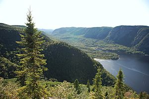
The river's upper part flows through the zec du Lac-au-Sable. This is a special area where hunting and fishing are managed. The lower part of the river runs through the Saguenay Fjord National Park. This park is a protected natural area and a very popular spot for tourists.
The main road serving the Éternité River area is Route 170. It goes through the village of Rivière-Éternité. Other smaller forest roads help people get to the lakes. These roads are used for logging and for fun outdoor activities like camping or hiking.
Logging is the most important economic activity in this area. Tourism and recreation come in second place. The Éternité River usually freezes over from late November to early April. However, it's generally safe to walk or travel on the ice from mid-December to the end of March.
River's Journey
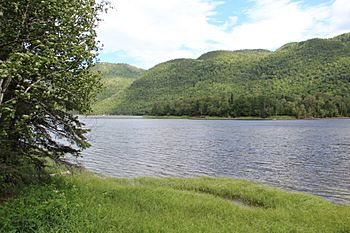
The Éternité River starts at Éternité Lake. This lake is about 9 kilometers (5.6 miles) long and sits 250 meters (820 feet) above sea level. The lake has an interesting shape, with one part looking like a giraffe's neck and head. The two parts of the lake connect near where Lake Bailloquet flows in. High mountains surround this lake.
The mouth of Éternité Lake is located:
- 14.3 kilometers (8.9 miles) west of where the Éternité River joins the bay.
- 11.6 kilometers (7.2 miles) south of the Saguenay River.
- 27.9 kilometers (17.3 miles) southeast of downtown La Baie.
The Éternité River flows mostly northeast for about 19.8 kilometers (12.3 miles). Here's how its journey unfolds:
- It flows 2.0 kilometers (1.2 miles) east to the outlet of Lake Périgny.
- Then, it goes 1.9 kilometers (1.2 miles) northeast. It crosses Little Eternity Lake for 0.7 kilometers (0.4 miles). This part also gets water from Hamel Lake, Huard Lake, and Trout Lake.
- Next, it travels 5.9 kilometers (3.7 miles) northeast to Benouche stream, which is in the village of Rivière-Éternité.
- Finally, it flows 10.0 kilometers (6.2 miles) northeast. It collects water from Price Lake, Riverine Lake, and Lac Côté. It then reaches the end of Éternité Bay (which is 3.0 kilometers or 1.9 miles long).
The mouth of the Éternité River is located:
- 5.0 kilometers (3.1 miles) south of a cape on the north shore of the Saguenay River.
- 49.0 kilometers (30.4 miles) west of Tadoussac.
- 7.2 kilometers (4.5 miles) northeast of the center of Rivière-Éternité village.
- 56.4 kilometers (35.0 miles) east of Saguenay city.
From the mouth of the Éternité River, the water flows 3.0 kilometers (1.9 miles) north through Éternité Bay. Then, it goes 65.4 kilometers (40.6 miles) east down the Saguenay River. Finally, it empties into the St. Lawrence River at Tadoussac.
River's Name History
The Commission de toponymie du Québec (Quebec's place name commission) has studied the river's name. A map from 1744 by Jacques-Nicolas Bellin called the river "Heregachitgs." This Amerindian name means "Trinity."
Later, in 1824, Captain Louis Sivrac mentioned the name "Ance d'Éternité." A map made in 1825 by Pascal Taché labeled the river as "Rve de l'Étrinité" (a slightly different spelling).
The commission also notes that the Éternité River is full of fish. It flows down from the Laurentian mountains for almost 20 kilometers (12.4 miles). It drains Éternité Lake, which is a long, narrow lake. Logging was an important activity along this river in the late 1800s.
Fish and Wildlife
The Éternité River is very important for a type of fish called the brook trout. These trout are also known as sea trout. They are "anadromous," which means they live in the ocean but travel up rivers to lay their eggs. The Éternité River provides a good place for these fish to reproduce.
 | Lonnie Johnson |
 | Granville Woods |
 | Lewis Howard Latimer |
 | James West |


