ǁKaras Region facts for kids
Quick facts for kids
ǁKaras Region
|
|
|---|---|
|
Region
|
|

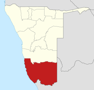
Location of the ǁKaras Region in Namibia
|
|
| Country | Namibia |
| Capital | Keetmanshoop |
| Area | |
| • Total | 161,514 km2 (62,361 sq mi) |
| Population
(2011)
|
|
| • Total | 77,421 |
| • Density | 0.479345/km2 (1.241499/sq mi) |
| Time zone | South African Standard Time: UTC+2 |
The ǁKaras Region is a large area located in the southern part of Namibia, a country in Africa. Its capital city is Keetmanshoop. This region is known for its unique landscapes and important natural features. The name of the region was changed in August 2013 to include the "ǁ" symbol. This symbol represents a special click sound found in some local languages.
Contents
About the ǁKaras Region
The ǁKaras Region is the southernmost region in Namibia. It is also the largest region in the country by land area. Despite its size, it has one of the smallest populations, meaning there are not many people living there. This makes it a place with vast open spaces and beautiful natural scenery.
Leadership in ǁKaras
The region is led by a person called a Governor. The Governor helps manage the region and works for its people. Since 2020, Aletta Fredericks has been the Governor of the ǁKaras Region.
Geography and Nature
The ǁKaras Region is home to some incredible natural landmarks.
- The Karas mountain range stretches across the southern part of the region. These mountains are an important part of the landscape.
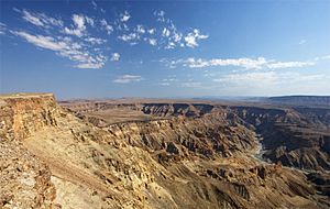
- One of the most famous natural attractions is the Fish River Canyon. It is one of the largest canyons in the world! This massive canyon was formed by the Fish River over millions of years. It's a popular spot for hiking and seeing amazing views.
Local Divisions: Constituencies
The ǁKaras Region is divided into smaller areas called constituencies. These are like local districts that help manage different parts of the region. There are seven constituencies in ǁKaras:
- Berseba
- Karasburg East
- Keetmanshoop Rural
- Keetmanshoop Urban
- ǃNamiǂNûs (This area was formerly known as Lüderitz Constituency)
- Oranjemund
- Karasburg West
Images for kids
See also
 In Spanish: Región de Karas para niños
 | William Lucy |
 | Charles Hayes |
 | Cleveland Robinson |


