Àger facts for kids
Quick facts for kids
Àger
|
||
|---|---|---|
|
Municipality
|
||

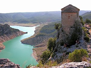
Mare de Déu de la Pertusa in Corçà
|
||
|
||
| Country | ||
| Community | ||
| Province | Lleida | |
| Comarca | Noguera | |
| Area | ||
| • Total | 160.6 km2 (62.0 sq mi) | |
| Elevation | 642 m (2,106 ft) | |
| Population
(2018)
|
||
| • Total | 611 | |
| • Density | 3.804/km2 (9.854/sq mi) | |
| Demonym(s) | Agerenc | |
| Postal code |
25691
|
|
Àger is a small town and a municipality in Catalonia, Spain. It's located in the Noguera area, which is like a county. Àger is in the northwest part of this area.
The land of Àger stretches between two important rivers: the Noguera Ribagorçana and the Noguera Pallaresa. You can also find the Terradets reservoir here, which is a large artificial lake on the Noguera Pallaresa river. The town is connected to nearby places like Balaguer and Tremp by the L-904 road.
Villages in Àger
The municipality of Àger includes several smaller villages. Here's a look at some of them and how many people live there:
- Àger town, with 317 inhabitants.
- Agulló, with 45 inhabitants.
- Corçà, with 32 inhabitants.
- Fontdepou, with 16 inhabitants.
- Els Masos de Millà, with 17 inhabitants.
- Millà, with 5 inhabitants.
- La Règola, with 21 inhabitants.
- Sant Josep de Fontdepou, with 19 inhabitants.
- Vilamajor, with 13 inhabitants.
See also
 In Spanish: Áger para niños
Black History Month on Kiddle
Renowned African-American Artists:
 | Kyle Baker |
 | Joseph Yoakum |
 | Laura Wheeler Waring |
 | Henry Ossawa Tanner |

All content from Kiddle encyclopedia articles (including the article images and facts) can be freely used under Attribution-ShareAlike license, unless stated otherwise. Cite this article:
Àger Facts for Kids. Kiddle Encyclopedia.


