Éparcy facts for kids
Quick facts for kids
Éparcy
|
|
|---|---|

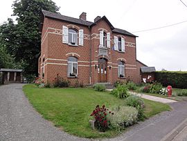
The town hall of Éparcy
|
|
| Country | France |
| Region | Hauts-de-France |
| Department | Aisne |
| Arrondissement | Vervins |
| Canton | Hirson |
| Intercommunality | CC Trois Rivières |
| Area
1
|
7.52 km2 (2.90 sq mi) |
| Population
(2008)
|
47 |
| • Density | 6.25/km2 (16.19/sq mi) |
| Time zone | UTC+01:00 (CET) |
| • Summer (DST) | UTC+02:00 (CEST) |
| INSEE/Postal code |
02278 /02500
|
| Elevation | 147–207 m (482–679 ft) (avg. 151 m or 495 ft) |
| 1 French Land Register data, which excludes lakes, ponds, glaciers > 1 km2 (0.386 sq mi or 247 acres) and river estuaries. | |
Éparcy is a very small commune in northern France. A commune is like a small town or village with its own local government. It is found in the Aisne department. The Aisne department is part of the region called Hauts-de-France.
Contents
Discover Éparcy!
Éparcy is a quiet place with a very small population. In 2008, only 47 people lived there. This makes it one of the smallest communes in France. It is a peaceful area, perfect for those who enjoy nature.
Where is Éparcy Located?
Éparcy is located in the northern part of France. It is in the Aisne department. This department is known for its green landscapes and historical sites. The closest larger town is Vervins.
Life in Éparcy
Life in Éparcy is very calm. The people who live there are part of a close-knit community. Even though it is small, Éparcy has its own town hall. This is where local decisions are made. The town hall building is shown in the picture above.
Who is the Mayor of Éparcy?
The mayor of Éparcy is Pascal Bailly. He was elected in 2008. A mayor is the leader of a commune. Their job is to manage the local government. They help make sure the town runs smoothly. This includes things like local services and community projects.
Éparcy's Geography
Éparcy covers an area of about 7.52 square kilometers (about 2.9 square miles). The land in Éparcy is not completely flat. Its elevation, or height above sea level, changes. The lowest point is 147 meters (482 feet) high. The highest point reaches 207 meters (679 feet). The average elevation is around 151 meters (495 feet).
See also
 In Spanish: Éparcy para niños
 | Lonnie Johnson |
 | Granville Woods |
 | Lewis Howard Latimer |
 | James West |


