ʻĀhuimanu facts for kids
Quick facts for kids
Ahuimanu
ʻĀhuimanu
|
|
|---|---|

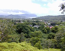
Ahuimanu looking towards Kaneohe Bay
|
|

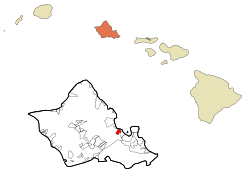
Location in Honolulu County and the state of Hawaii
|
|
| Country | |
| State | |
| County | Honolulu |
| Area | |
| • Total | 2.69 sq mi (6.98 km2) |
| • Land | 2.69 sq mi (6.98 km2) |
| • Water | 0.00 sq mi (0.00 km2) |
| Elevation | 82 ft (25 m) |
| Population
(2020)
|
|
| • Total | 8,969 |
| • Density | 3,329.25/sq mi (1,285.20/km2) |
| Time zone | UTC-10 (Hawaii-Aleutian) |
| ZIP code |
96744
|
| Area code(s) | 808 |
| FIPS code | 15-00400 |
| GNIS feature ID | 0358445 |
Ahuimanu or ʻĀhuimanu is a special type of community in Hawaii, called a census-designated place (CDP). It is located on the island of Oahu, within the City & County of Honolulu. In the Hawaiian language, ʻāhui-manu means "cluster of birds."
Ahuimanu sits at the base of the tall, windy cliffs of the Koolau mountains. It is separated from Heeia Kea by a small hill. This means most of Ahuimanu is inland, not directly on Kaneohe Bay. However, one part of the community extends over the hill and along Kamehameha Highway, offering private access to the bay. Being close to the cliffs makes the area quite wet. In 2010, this mostly residential area had about 8,810 people living there. You can also find a small shopping area here, right across the highway from the Valley of the Temples Memorial Park. This park is a large cemetery known for its beautiful Byodo-In Temple.
The U.S. postal code for Ahuimanu is 96744.
Where is Ahuimanu?
Ahuimanu is found on the east side of Oahu, Hawaii. Its exact location is 21°26′36″N 157°50′24″W / 21.44333°N 157.84000°W. Nearby communities include Heeia and Kaneohe to the south, along State Route 83. To the north, it blends into Kahaluu.
The United States Census Bureau says that Ahuimanu covers a total area of about 7.0 square kilometers (2.7 square miles), and all of it is land.
Who Lives in Ahuimanu?
| Historical population | |||
|---|---|---|---|
| Census | Pop. | %± | |
| 2020 | 8,969 | — | |
| U.S. Decennial Census | |||
In 2010, there were 8,810 people living in Ahuimanu. This meant about 3,270 people lived in each square mile. There were 2,745 households, and most of them (2,246) were families. Almost all of the homes (97.1%) were occupied.
People from many different backgrounds live in Ahuimanu. In 2010, about 22% of the people were White, 31.1% were Asian, and 9.6% were Native Hawaiian or other Pacific Islanders. About 36.2% of the people identified as being from two or more races. Around 9.4% of the population was of Hispanic or Latino background.
Many households (40.4%) had children under 18 living with them. Most households (63.8%) were made up of married couples living together. The average household had about 3.19 people.
The average age of people in Ahuimanu was 39.2 years. About 11.7% of the population was 65 years old or older.
In 2013-2017, the average income for a household in Ahuimanu was $103,825. The average income per person was $39,940. About 5.2% of the people in Ahuimanu had lower incomes.
Schools in Ahuimanu
| Ahuimanu Elementary School | |
|---|---|
| Address | |
|
47-470 Hui Aeko Place
Kaneohe
,
96744
United States
|
|
| Information | |
| Type | Public elementary school |
| Established | 1973 |
| School district | Windward Oahu |
| Principal | Randolph Scoville |
| Faculty | 50 |
| Grades | K-6 |
| Enrollment | 400 |
| Nickname | Kolea |
| Newspaper | Kani Kolea newsletter |
| Website | School site |
Ahuimanu Elementary School is a public school for students from kindergarten to 6th grade. It is part of the Hawai'i State Department of Education. The school serves about 400 students. It is located in the Temple Valley community of Ahuimanu, near the Ko'olau mountains.
Another important school, Saint Louis School, was first located in the ʻĀhuimanu area. It was called the College of ʻĀhuimanu and was started in 1846. Later, in 1881, the school moved to Honolulu.
See also
 In Spanish: Ahuimanu para niños
 | Delilah Pierce |
 | Gordon Parks |
 | Augusta Savage |
 | Charles Ethan Porter |

