Heʻeia, Hawaii facts for kids
Quick facts for kids
Heeia
Heʻeia
|
|
|---|---|

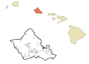
Location in Honolulu County and the state of Hawaii
|
|
| Country | United States |
| State | Hawaii |
| Area | |
| • Total | 3.45 sq mi (8.94 km2) |
| • Land | 3.20 sq mi (8.29 km2) |
| • Water | 0.25 sq mi (0.65 km2) |
| Elevation | 13 ft (4 m) |
| Population
(2020)
|
|
| • Total | 5,001 |
| • Density | 1,562.32/sq mi (603.24/km2) |
| Time zone | UTC-10 (Hawaii-Aleutian) |
| ZIP code |
96744
|
| Area code(s) | 808 |
| FIPS code | 15-13900 |
| GNIS feature ID | 0359149 |
Heʻeia (pronounced hɛˈʔɛjə) is a special kind of community in Hawaii. It's called a census-designated place, which means it's an area grouped together for counting people, but it's not an official city or town. Heʻeia is located in Honolulu County on the island of Oʻahu.
The name Heʻeia comes from Hawaiian words that mean "washed away." This name might refer to an old story about a victory where a tsunami helped people from Heʻeia win a battle.
Heʻeia is mostly made up of homes and apartments. Some parts of Heʻeia are along Kāneʻohe Bay, but these areas are privately owned. This means there isn't public access to the shore there.
Contents
Exploring Heʻeia
Heʻeia includes a few interesting spots. These places have unique histories or features that make Heʻeia special.
Haʻikū Valley and Stairs
Haʻikū Valley is part of Heʻeia. It used to be a radio transmitter site for the United States Coast Guard. This valley is also known for the Haiku Stairs, which are a very steep and challenging hiking trail.
Station HYPO's Antenna Site
Heʻeia was once home to the receiving antenna for Station HYPO. This was a secret naval station that played a huge role in World War II. Station HYPO helped break Japanese naval codes in 1941-1942. This secret work helped the U.S. win the Battle of Midway. Many historians believe this battle was a major turning point in the war in the Pacific Ocean. The station got its name, HYPO, from the letter "H" in Heʻeia.
Heʻeia Fishpond
The Heʻeia Fishpond is another important site. It is the largest remaining traditional Hawaiian fishpond on Oʻahu. These fishponds were used for Hawaiian aquaculture, which is a way of raising fish in enclosed areas.
Heʻeia Kea Community
Heʻeia Kea is a nearby community. It's separated from Heʻeia by Heʻeia Marsh and Kealohi Point. Here you'll find the Heʻeia Kea Small Boat Harbor. This is the only public pier and boat ramp on Kāneʻohe Bay. In recent years, some old fishponds in this area have been restored. While fishponds were built on most Hawaiian islands, the biggest groups were found in Kāneʻohe Bay, Pearl Harbor, and Keʻehi Lagoon on Oʻahu.
The ZIP code for both Heʻeia and Heʻeia Kea is 96744, which is the same as for Kāneʻohe.
Geography of Heʻeia
Heʻeia is located at coordinates 21°25′34″N 157°48′44″W / 21.42611°N 157.81222°W. It's very close to, and often considered part of, Kāneʻohe. To the northwest, you can reach the town of ʻĀhuimanu. You can get there by taking either Kahekili Highway (State Rte. 83) or Kamehameha Highway (State Rte. 830) along the coast.
The area of Heʻeia covers about 8.7 square kilometers (3.4 square miles). Most of this area, about 8.0 square kilometers (3.1 square miles), is land. The rest, about 0.7 square kilometers (0.3 square miles), is water. This means about 7.54% of Heʻeia's total area is water.
People of Heʻeia
| Historical population | |||
|---|---|---|---|
| Census | Pop. | %± | |
| 2020 | 5,001 | — | |
| U.S. Decennial Census | |||
In 2020, the population of Heʻeia was 5,001 people. Back in 2000, there were 4,944 people living here.
In 2000, about 28% of households in Heʻeia had children under 18. Most households, about 73.2%, were married couples living together. The average household had about 3.17 people.
The population in 2000 was spread out by age:
- About 21.4% were under 18 years old.
- About 6.9% were between 18 and 24.
- About 24.4% were between 25 and 44.
- About 31.5% were between 45 and 64.
- About 15.8% were 65 years or older.
The average age in Heʻeia was 43 years.
Education in Heʻeia
The Hawaii Department of Education is in charge of the public schools in Hawaii.
Governor Samuel Wilder King Intermediate School is located right in Heʻeia. Heʻeia Elementary School is in the nearby Kaneohe area. The Roman Catholic Diocese of Honolulu also runs St. Ann Catholic School in Heʻeia, which teaches students from kindergarten through 8th grade.
See also
 In Spanish: Heeia para niños
 | Chris Smalls |
 | Fred Hampton |
 | Ralph Abernathy |

