
2016 Kaikoura earthquake facts for kids

|
|
| UTC time | 2016-11-13 11:02:56 |
|---|---|
| ISC event | 609815006 |
| USGS-ANSS | ComCat |
| Local date | 14 November 2016 |
| Local time | 00:02:56 NZDT |
| Magnitude | 7.8 Mw |
| Depth | 15 km (9 miles) |
| Epicenter | 42°45′25″S 173°04′37″E / 42.757°S 173.077°E 15 km (9 miles) north-east of Culverden |
| Type | Oblique-slip |
| Areas affected | New Zealand |
| Max. intensity | IX (Violent) |
| Tsunami | Yes |
| Aftershocks | > 20,200 (as of 22 November 2017) |
| Casualties | 2 dead 57 treated for injuries |


The 2016 Kaikoura earthquake was a very strong earthquake that hit the South Island of New Zealand. It happened just after midnight on 14 November 2016. The earthquake's strength was measured at 7.8 on the Moment magnitude scale.
The place where the earthquake started, called the epicentre, was about 15 kilometres (9 miles) deep. It was located near the town of Culverden and not far from the tourist town of Kaikoura. The ground shook for more than a minute. This earthquake was one of the biggest in the world that year.
Contents
What Happened During the Earthquake?
The Kaikoura earthquake was caused by several faults breaking at the same time. This is unusual for an earthquake. The ground moved in a complex way, causing different types of damage.
Ground Movement and Damage
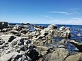
The earthquake caused the ground to move a lot. Some areas of the coast were pushed upwards by several metres. This uplift changed the shoreline and affected sea life. Roads and railway lines were badly damaged, especially along the coast.
Many buildings were also damaged, particularly in the Kaikoura area. Some buildings in the capital city, Wellington, also suffered damage. People felt the shaking across a large part of New Zealand.
Tsunami and Aftershocks
A small tsunami was also created by the earthquake. It caused waves to hit the coast, but they were not very large. After the main earthquake, there were many smaller earthquakes called aftershocks. Over 20,200 aftershocks were recorded in the year that followed.
Impact on People and Nature
The earthquake had a big impact on the people and the environment. Two people sadly lost their lives. Many others needed medical help for injuries.
Effects on Coastal Life
The sudden uplift of the coastline had a huge effect on sea creatures. Animals like kelp and shellfish that lived in the water were suddenly exposed to the air. This led to many of them dying. The changed coastline also made it harder for some birds to find food.
Getting Help and Supplies
Because roads were cut off, it was hard to get supplies to Kaikoura. The New Zealand Navy and other countries helped. They used ships and helicopters to bring food, water, and other important items. They also helped people leave the affected areas if they needed to.
Recovery and Rebuilding
After the earthquake, a lot of work was needed to fix the damage. Roads and railway lines had to be rebuilt. This was a huge task because of the difficult terrain. Many damaged buildings also needed to be repaired or taken down.
The community of Kaikoura worked hard to recover. People helped each other, and the government provided support. The rebuilding efforts continued for a long time after the earthquake.
Images for kids
-
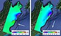
Satellite radar image showing ground motion effects during the earthquake
-
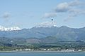
Morning supply run from USS Sampson helicopter
-
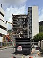
Demolition of building on Molesworth Street, Wellington
-
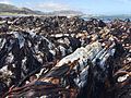
Earthquake uplift at coastal sites resulted in large-scale die offs of intertidal organisms such as Durvillaea kelp
-
Uplift measured in the intertidal zone at Kaikōura
-
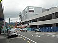
Demolition of the damaged cinema and parking building at Queensgate Shopping Centre, Lower Hutt
-
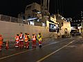
Baggage of evacuees being unloaded off HMNZS Canterbury
-
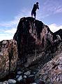
Uplifted shoreline on the Kaikōura Peninsula in 2020
-
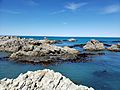
Uplifted shoreline at Ward Beach in 2020

.jpg)


See also
 In Spanish: Terremoto de North Canterbury de 2016 para niños
