
Aboriginal sites of Victoria facts for kids
Aboriginal sites in Victoria are special places that show us how people lived for over 40,000 years. These sites are found through old tools, stories, and traditions. They include places where important ceremonies happened, where people lived, ate, and slept, and even where a tool might have been dropped long ago.

You can find many types of sites like shell piles (middens), trees with marks, old cooking places, rock art, burial sites, and special ceremony spots. There are also countless stone tools. These stone tools include knives, spear points, scrapers, and other items. The leftover pieces from making these tools are called "stone artefact scatters." You can find them on the ground, or they might be uncovered by farming or digging.
Contents
Types of Aboriginal Sites
Scarred Trees
Scarred trees are trees where Aboriginal people removed bark. They used this bark to make things like shields, bowls (coolamons), and shelters. Some trees even have special designs carved into them. For example, a large river red gum tree at Heide Gallery in Bulleen has a scar from where bark was taken to make a canoe.

Rock Art
More than 60 rock art sites have been found in the Grampians National Park. This park has about 80% of all known Aboriginal rock art in Victoria. Many new discoveries were made after fires in 2006. The art shows people, hands, animal tracks, and birds. Some sites are open for visitors, like Billimina, Manja (Cave of Hands), and Gulgurn Manja (Flat Rock).
Nearby, Bunjil's Shelter shows Bunjil, who is the creator in Aboriginal beliefs. This site is in the Black Range near Stawell. At Mt Pilot, there's a painting that might be of a thylacine (Tasmanian tiger). Paintings at Mudgegonga rock shelter in north-eastern Victoria could be 3500 years old.
Ceremonial Sites
Ceremonial sites are places where special rituals and gatherings took place. Two large stone arrangements have been found at Wurdi Youang near Mount Rothwell and at Carisbrook. Other sites are known from old stories, even if the physical evidence is gone. For example, the Corroboree Tree at Richmond oval was an important meeting place for the Wurundjeri people.

Several earth rings have been found in Sunbury. These rings are thought to be ceremonial Bora rings, used for important ceremonies.
Stone Quarries
Places where Aboriginal people dug for stone to make tools are rare. The Mount William stone axe quarry is one such place. Stone from here was traded over long distances across Victoria and into New South Wales.

Burial Sites
Only a small number of burial sites have been found in Victoria. Most are in sand dunes along the coast or in the north-west of the state. Kow Swamp is very important. It shows burial rituals from 13,000 years ago, including headbands made of kangaroo teeth. A burial found near the Werribee River is about 7300 years old.
Shell Middens
Shell middens are piles of shells left behind by Aboriginal people after eating shellfish. You can find them along most of the coastline and near some lakes and rivers. Many middens are relatively new, but some are very old. For example, middens at Mallacoota are over 2500 years old, and those at Wilsons Promontory are 6500 years old.
Earth Mounds
Large earth mounds were built up over time from soil and the remains of old fireplaces. They also include collapsed huts and camp activities. Examples have been found on the Hopkins River flood plain and in the Nyah Forest. The oldest mound is about 2500 years old.
Fish and Eel Traps
Aboriginal people built fish and eel traps on many rivers. Most were made of natural materials that have disappeared. However, some, like those at Lake Condah in western Victoria, show complex systems of channels and stone walls. These traps are about 3000 years old.
Stone tools found near the bones of giant animals (megafauna) at Lancefield suggest that Aboriginal people lived alongside these huge creatures 26,000 years ago.
Rock Shelters
Rock shelters are natural caves or overhangs that were used as homes. They often have cave paintings and other art. They are also good places to find old remains because they are protected from weather. New Guinea II cave on the Snowy River has remains over 10,000 years old, along with delicate cave paintings. Rock shelters in the Cape Bridgewater area were used about 12,000 years ago.
Cloggs Cave near Buchan was used about 18,000 years ago, where bone tools and animal remains were found. At the Keilor Archaeological Site, a human fireplace found in 1971 was dated to about 31,000 years ago. This makes Keilor one of the oldest places where people lived in Australia. At Box Gully on Lake Tyrrell, emu eggs and other items are 27,000 years old.
Stone Artefact Scatters
Stone artefact scatters are very common sites. They show where tools were made and used. These sites often have many small pieces of stone, which are waste from making tools. Different types of tools, like blades or scrapers, can tell us what the area was used for, such as preparing animal skins. The stone used was often silcrete, chert, and quartz.
How Old Are These Sites?
Archaeological evidence suggests that people first arrived in Australia around 50,000 years ago. They came to Victoria shortly after. Sites over 22,000 years old have been found at Kow Swamp and the Keilor archaeological site. A human skull found at Keilor is between 12,000 and 14,700 years old.
The Keilor site, located on the Maribyrnong River, is the oldest archaeological site in the greater Melbourne area. A human skull found there in 1940 was later found to be around 13,000 years old. This discovery was very important worldwide. Later excavations found many stone tools and animal bones.
Where Did People Live?
Most evidence of Aboriginal settlement comes from camp sites. These sites have fireplaces, remains of stone tool making, and sometimes structures like mounds and huts. They are almost always found near reliable water sources.
Aboriginal archaeological sites show that people lived in all parts of Victoria. This was true even during the coldest times of the Last Glacial Maximum. At that time, temperatures were much colder, and sea levels were lower. Even with these big climate changes, people were present in south-eastern Australia for at least the last 30,000 years. They lived in deep gorges, highlands, river plains, inland swamps, and eastern ranges like the Grampians.
Protecting Aboriginal Heritage
All Aboriginal archaeological sites and relics in Victoria are protected by the Aboriginal Heritage Act 2006. This law is managed by Aboriginal Affairs Victoria. All known sites are recorded on the Victorian Aboriginal Heritage Register. So far, about 30,000 places and objects are on this register.
Images for kids
-
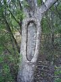
Scar tree from removal of bark for a shield, near Wahgunyah
-
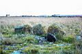
A small part of the Wurdi Youang stone arrangement
-
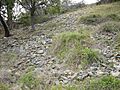
Mount William Quarry
