
Abra (province) facts for kids
Quick facts for kids
Abra
|
|||
|---|---|---|---|
| Province of Abra | |||

Abra Provincial Capitol
|
|||
|
|||

Location in the Philippines
|
|||
| Region | Cordillera Administrative Region | ||
| Founded | 10 March 1917 | ||
| Capital | Bangued | ||
| Government | |||
| • Type | Sangguniang Panlalawigan | ||
| Area | |||
| • Total | 4,165.25 km2 (1,608.21 sq mi) | ||
| Area rank | 29th out of 81 | ||
| Highest elevation
(Mount Bangbanglang)
|
2,454 m (8,051 ft) | ||
| Population
(2020 census)
|
|||
| • Total | 250,985 | ||
| • Rank | 68th out of 81 | ||
| • Density | 60.25689/km2 (156.0646/sq mi) | ||
| • Density rank | 80th out of 81 | ||
| Divisions | |||
| • Independent cities | 0 | ||
| • Component cities | 0 | ||
| • Municipalities |
27
|
||
| • Barangays | 303 | ||
| • Districts | Lone District of Abra | ||
| Time zone | UTC+8 (PHT) | ||
| ZIP code |
2800–2826
|
||
| IDD : area code | +63 (0)74 | ||
| ISO 3166 code | PH-ABR | ||
| Spoken languages | |||
| Website | www |
||


Abra is a beautiful province in the Philippines. It is located in the Cordillera Administrative Region on the island of Luzon. The capital city of Abra is Bangued. Abra shares its borders with several other provinces. To the northwest is Ilocos Norte, and to the northeast is Apayao. On its eastern side, you'll find Kalinga and Mountain Province. To the southwest, it borders Ilocos Sur.
Contents
Exploring Abra Province
Abra is a landlocked province. This means it has no direct access to the sea. It is mostly made up of mountains and hills. The Abra River is the biggest river in the province. It flows from the mountains of Mountain Province all the way to the South China Sea.
Geography and Nature
Abra covers a total area of about 4,165 square kilometers. This makes it the 29th largest province in the Philippines. The highest point in Abra is Mount Bangbanglang. It stands tall at 2,454 meters above sea level. The province is known for its rugged terrain and beautiful natural scenery.
People and Culture
As of the 2020 census, about 250,985 people live in Abra. Most people in Abra speak the Ilocano language. Other languages spoken include Tinguian and Isneg. The people of Abra are known for their rich culture and traditions.
How Abra is Governed
Abra is led by a Governor and a Vice Governor. These leaders work with the Sangguniang Panlalawigan, which is like a provincial council. They help manage the province and make decisions for its people. The capital, Bangued, is where the main government offices are located.
Towns and Barangays
Abra has 27 different towns, also called municipalities. These towns are divided into smaller areas called barangays. There are 303 barangays in total across the province. Each town and barangay has its own local leaders.
- Bangued
- Boliney
- Bucay
- Bucloc
- Daguioman
- Danglas
- Dolores
- La Paz
- Lacub
- Lagangilang
- Lagayan
- Langiden
- Licuan-Baay
- Luba
- Malibcong
- Manabo
- Peñarrubia
- Pidigan
- Pilar
- Sallapadan
- San Isidro
- San Juan
- San Quintin
- Tayum
- Tineg
- Tubo
- Villaviciosa
Images for kids
-
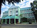
Abra Provincial Capitol
-
Flag of Abra
-
Seal of Abra
-
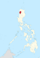
Map showing Abra's location in the Philippines
See also
 In Spanish: El Abra (Filipinas) para niños
