
Apayao facts for kids
Quick facts for kids
Apayao
|
|||
|---|---|---|---|
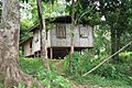
   (from top: left to right) Abulog River in Kabugao, Dibagat home and Pudtol church ruins.
|
|||
|
|||

Location in the Philippines
|
|||
|
OpenStreetMap
|
|||
| Country | Philippines | ||
| Region | Cordillera Administrative Region | ||
| Founded | May 8, 1995 | ||
| Capital | Kabugao* | ||
| Administrative center | Luna | ||
| Largest municipality | Conner | ||
| Area | |||
| • Total | 4,413.35 km2 (1,704.00 sq mi) | ||
| Area rank | 27th out of 81 | ||
| Highest elevation
(Mount Lungod)
|
1,921 m (6,302 ft) | ||
| Population
(2020 census)
|
|||
| • Total | 124,366 | ||
| • Estimate
(2020)
|
123,898 | ||
| • Rank | 78th out of 81 | ||
| • Density | 28.17950/km2 (72.9846/sq mi) | ||
| • Density rank | 81st out of 81 | ||
| Demonym(s) |
|
||
| Divisions | |||
| • Independent cities | 0 | ||
| • Component cities | 0 | ||
| • Municipalities |
7
|
||
| • Barangays | 133 | ||
| • Districts | Legislative district of Apayao | ||
| Time zone | UTC+8 (PHT) | ||
| IDD : area code | +63 (0)74 | ||
| ISO 3166 code | PH-APA | ||
| Spoken languages | |||
| Website | www |
||
| * Kabugao is the officially recognized capital and seat of government, although the province carries out many of its operations in a new government center established in Luna. | |||


Apayao is a province in the Philippines. It is located in the Cordillera Administrative Region on Luzon Island. Apayao is a landlocked province, meaning it doesn't have a coastline. Its official capital is Kabugao, but many government offices are in Luna.
The province shares borders with Cagayan to the north and east. To the west, it borders Abra and Ilocos Norte. To the south, it borders Kalinga. Before 1995, Apayao and Kalinga were one province called Kalinga-Apayao. They separated to better serve the different groups of people living there.
Apayao has a population of about 124,366 people, based on the 2020 census. It covers an area of 4,413.35 square kilometers. This makes Apayao the least crowded province in the Philippines. It is also one of the least developed provinces in Luzon.
Apayao's Past: A Look at History
By the 20th century, the Isneg people were the main group living in Apayao. Most of them lived in the mountain towns of Kabugao and Calanasan. They settled along the Apayao-Abulug River and a part of the Matalag River in Conner.
Spanish Rule and Early Missions
Apayao was part of Cagayan during the Spanish colonial era. It was one of the first areas in the Cordilleras that the Spanish tried to control. However, the Isneg tribe largely remained free from Spanish rule until the late 1800s.
In 1610, Dominican friars built a mission in what is now Pudtol. Later, in 1684, they tried again to convert the people and built a church in Kabugao.
By 1891, the Spanish set up military districts called comandancias in Apayao and Cabugaoan. These covered the western and eastern parts of what is now Apayao. But these districts did not give the Spanish full control over the area.
American Rule and Changes
Apayao became a sub-province of Cagayan on May 9, 1907, through Act No. 1642. This was during the American colonial era in the Philippines.
On August 13, 1908, the Americans created the Mountain Province. Apayao became one of its sub-provinces, along with Amburayan, Benguet, Bontoc, Ifugao, Kalinga, and Lepanto.
Over the years, Apayao's borders changed a few times:
- In 1920, a part of Apayao was moved to Ilocos Norte.
- In 1927, parts of Pinukpuk in Kalinga were added to Conner.
- In 1929, Luna was created as a separate district from Tauit.
- In 1936, Tauit was removed as a district and became part of Luna.
- In 1937, Namaltugan was removed and added to Bayag and Kabugao.
In these early years, Apayao was divided into seven municipal districts. Most of the people in these districts were Isneg.
Japanese Occupation During World War II
In 1942, Japanese Imperial forces entered Apayao. They occupied the province for three years during World War II. Local Filipino soldiers and guerrillas fought against the Japanese. They drove the Japanese out in 1945.
During the war, Kabugao was occupied by the Japanese for a year. An Isneg guerrilla group was formed to fight them. Not much fighting happened directly in Apayao, but many Isneg people fought with American and Filipino forces in the Cagayan Valley.
After World War II: Kalinga-Apayao and Its Split
On June 18, 1966, the large Mountain Province was divided into four new provinces. These were Benguet, Bontoc (now called "Mountain Province"), Kalinga-Apayao, and Ifugao. Kalinga-Apayao became part of the Cagayan Valley region in 1972.
Apayao During the Marcos Era
The 1970s were a time of big changes in the Philippines, including Kalinga-Apayao. President Ferdinand Marcos started many public projects, which led to economic problems. In September 1972, he declared Martial Law. This allowed him to stay in power for 14 more years.
During this time, many people who spoke out against the government faced human rights abuses. Kalinga-Apayao became a place of conflict because of the Chico River Dam Project. This project would have flooded many towns and forced about 100,000 indigenous people to move. Marcos sent soldiers to stop protests, which made tensions rise.
Apayao was greatly affected by these events. This included the fight against the Chico Dam Project and the struggle against logging companies taking over indigenous lands. Many armed groups also rose up to fight for Cordilleran self-rule.
After the People Power Revolution
In 1986, the People Power Revolution removed Marcos from power. Many activists who had been fighting underground came out. The new government, led by President Corazon Aquino, released political prisoners and started peace talks. However, these talks eventually failed.
Another important event in 1986 was the Cordillera People's Liberation Army (CPLA) separating from the New People's Army. Their leader, Conrado Balweg, believed that the interests of the Igorot people were better served by fighting for regional self-rule. This led to talks that helped create the Cordillera Administrative Region.
Peace and the Cordillera Administrative Region
In September 1986, the CPLA signed the Mount Data Peace Accord with the government. This agreement led to the creation of the Cordillera Administrative Region on July 15, 1987. Kalinga-Apayao became one of its provinces.
Finally, on February 14, 1995, Kalinga-Apayao was officially split into two separate provinces: Kalinga and Apayao. This happened with the passing of Republic Act No. 7878.
Apayao's Natural Beauty: Geography and Climate
Apayao is located within the Cordillera Central mountains. Many rivers flow through the province. It covers an area of 4,413.35 square kilometers. Apayao forms the northern tip of the Cordillera Administrative Region.
The province is divided into two main parts:
- Upper Apayao: This includes the mountain towns of Calanasan, Conner, and Kabugao.
- Lower Apayao: This includes the lowland towns of Luna, Pudtol, Flora, and Santa Marcela.
Plains and valleys in Apayao are used for farming. Much of Apayao is made up of farmlands.
Apayao's Weather Patterns
Apayao has a climate with both dry and wet seasons. The dry season is from November to April. The rest of the year is wet. The heaviest rains usually fall from December to February. May is typically the warmest month.
Amazing Wildlife: Biodiversity in Apayao
Apayao is rich in different kinds of plants and animals. It is a safe home for 139 bird species. Of these, 61 are found only in the Philippines, and 4 are endangered. The province also has 43 types of wild plants that local people eat. There are also 50 kinds of medicinal plants.
Apayao is home to some very special and rare species. These include the critically endangered rufous hornbills, large lawaan trees, giant Raflesia flowers, and the white-winged flying fox.
The Philippine Eagle Foundation started looking for eagles in Apayao in 2011. People had reported seeing huge eagles in the area for centuries. On March 22, 2013, scientists found a strong group of critically endangered Philippine eagles in the Calanasan Lowland Forest on Luzon island. In January 2015, the town of Calanasan started a program to protect 3,000 hectares of its forests. Apayao is also one of the few provinces with an approved plan for how its forest land should be used. The first active Philippine eagle nest in Apayao was found in July 2015.
Apayao as a UNESCO Biosphere Reserve
On July 9, 2018, the government of Apayao announced its plan for the province to become a UNESCO Biosphere Reserve. Apayao has over 286,000 hectares of untouched forests. The province also sent four staff members to train in the United States to help speed up this declaration. On January 16, 2019, the provincial government said they were working hard to make it happen.
In July 2024, UNESCO officially listed Apayao's 3,960 square kilometers of lush forest areas, including the Apayao River, as a Biosphere Reserve. This makes Apayao the fourth biosphere reserve in the Philippines.
How Apayao is Governed: Administrative Divisions
Apayao has 7 municipalities. All of these are part of one legislative district.

The municipalities are:
- Calanasan
- Conner
- Flora
- Kabugao (the capital)
- Luna
- Pudtol
- Santa Marcela
Local Communities: Barangays
The 7 municipalities in Apayao have a total of 133 barangays. A barangay is the smallest local government unit in the Philippines. In 2015, Barangay Malama in Conner had the most people. Eleazar in Calanasan had the fewest.
Who Lives in Apayao: Demographics
In 2020, the population of Apayao was 124,366 people. This means there were about 28 people living in each square kilometer.
|
||||||||||||||||||||||||||||||||||||||||||||||||||||||||||||||||||||||

According to the 2000 census, Ilocanos made up about 50.82% of the population. The Isnag people were the second largest group, making up almost one-third of the population (29.95%). Other groups living in Apayao include the Malaueg, Itneg, Kalinga, Kankanaey, Bontoc, and Ibaloi.
Languages Spoken in Apayao
The main languages spoken in Apayao are Ilocano and Isnag.
How Apayao Makes Money: Economy
|
||||
Apayao's economy is mostly based on agriculture. Farmers grow food crops like palay (rice), corn, coffee, root crops, and vegetables. They also grow fruits such as lanzones, citrus, bananas, pineapples, durian, santol, rambutan, coconut, and mangosteen. In 2011, Apayao produced 98,489 metric tons of rice. Some parts of Apayao also have beautiful rice terraces.
People in Apayao also raise livestock and poultry. This includes pigs, carabaos (water buffalo), cattle, goats, and sheep. Other businesses in the province include making furniture, clothes, food products, gifts, and housewares.
The Department of Trade and Industry reports that Apayao has industries in furniture, garment crafts, food processing, and agricultural support. The people of Apayao also have a rich tradition of weaving baskets, handicrafts, and textiles.
Images for kids
-
Native Dibagat homes
See also
 In Spanish: Apayao para niños
