
Ada Covered Bridge facts for kids
|
Ada Covered Bridge
|
|

Upstream view from observation deck in park
|
|

Location in Michigan

Location in the United States
|
|
| Location | 7490 Thornapple River Dr SE Ada, MI 49301 |
|---|---|
| Area | 2 acres (0.81 ha) |
| Built | 1867 |
| Architect | Josiah Brown Jr. |
| Architectural style | Brown truss Covered bridge |
| NRHP reference No. | 70000275 |
Quick facts for kids Significant dates |
|
| Added to NRHP | February 16, 1970 |
| Bridge Statistics | |
|---|---|
| Carries | Fase/Bronson St. (footpath) |
| Crosses | Thornapple River |
| Locale | Ada, Michigan |
| Maintained by | Kent County Road Commission |
| Website | Leonard Park |
| Characteristics | |
| Design | Brown truss Covered bridge |
| Material | Douglas Fir |
| Total length | 125 ft |
| Width | one lane |
| Longest span | 125 ft |
| History | |
| Opened | 1867 |
| Rebuilt | December 1980 |
| Closed | still open, foot traffic only |
The Ada Covered Bridge is a special old bridge in Ada, Michigan, USA. It's a "covered bridge," which means it has a roof and walls, just like a house! This bridge is 125 feet (about 38 meters) long. It was built way back in 1867. The bridge crosses the Thornapple River. It's also listed on the National Register of Historic Places, which means it's an important historical site.
Contents
What Makes This Bridge Special?
The Brown Truss Design
The Ada Covered Bridge uses a special building method called the "Brown truss system." This system was invented and patented by Josiah Brown Jr. in 1857. It uses strong diagonal beams and almost vertical pieces that lean inward. These parts work together to make the bridge very strong. During repairs in 1913, a piece of wood with Brown's name on it was found!
The bridge is 125 feet (38 meters) long. When it was first built, it sat on wooden posts. Like most covered bridges, its roof is covered with special shingles. These shingles help protect the wood underneath from rain and snow.
A Look Back: The Bridge's History
Building the Bridge
The Michigan State Legislature gave Ada Township permission to borrow money. They could borrow up to $3,000 to build or fix bridges. This bridge, sometimes called the "Bradfield Bridge," was built in 1867. A person named William Holmes was in charge of building it.
Dealing with Floods
Before a dam was built upstream, the Thornapple River often flooded. A historical sign at the bridge tells a cool story. It says that farmers would drive wagons full of stones onto the bridge. They did this during high water to keep the bridge from floating away!
Changes Over Time
In 1913, the bridge was repaired. Its wooden supports were replaced with strong concrete. The bridge was a key route into Ada village until 1930. That's when a new main highway was built, and a concrete bridge replaced it. After that, the Ada Covered Bridge was closed to cars. It became a bridge just for people walking.
In 1941, more big repairs happened. The roof got new shingles, and many old, weak supports were replaced. The Road Commission even bought wood from a nearby barn for the repairs.
Becoming a Historic Site
The bridge was recognized as a Michigan State Register site in 1969. Then, in 1970, it was added to the National Register of Historic Places. It also got a Michigan Historical Marker in 1974. It is one of only four covered bridges in Michigan that are owned by the public.
Rebuilding After Disasters
In 1979, heavy snow caused the roof to collapse. People raised money through donations to fix it. But soon after the repairs, the bridge was completely destroyed by fire! The community didn't give up. With help from the Amway company, they rebuilt it again. The new bridge looks just like the old one. It is 14 feet (4.3 meters) wide and 125 feet (38 meters) long.
Today, the bridge is only for people walking. It connects the village of Ada to a park on the other side of the Thornapple River. The Kent County Park system takes care of it.
Images for kids
-
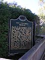
Historical Marker at the site.
-
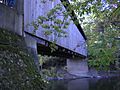
Underside view, showing truss ends protruding from the sheathing.
-
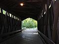
Inside, showing Brown truss stringers.


