Advance, Michigan facts for kids
Quick facts for kids
Advance, Michigan
|
|
|---|---|

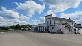
Sommerset General Store on Lake Shore Drive
|
|

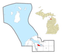
Location within Charlevoix County
|
|
| Country | United States |
| State | Michigan |
| County | Charlevoix |
| Township | Eveline |
| Settled | 1865 |
| Area | |
| • Total | 2.75 sq mi (7.12 km2) |
| • Land | 2.72 sq mi (7.04 km2) |
| • Water | 0.03 sq mi (0.07 km2) |
| Elevation | 598 ft (182 m) |
| Population
(2020)
|
|
| • Total | 340 |
| • Density | 125.00/sq mi (48.26/km2) |
| Time zone | UTC-5 (Eastern (EST)) |
| • Summer (DST) | UTC-4 (EDT) |
| ZIP code(s) |
49712 (Boyne City)
|
| Area code(s) | 231 |
| FIPS code | 26-00480 |
| GNIS feature ID | 0619851 |
Advance is a small community in Charlevoix County, Michigan, in the United States. It is an unincorporated community, meaning it doesn't have its own local government like a city or town. However, it is also a census-designated place (CDP). This means the government defines its borders and counts its population for official records.
In 2020, about 340 people lived in Advance. The community is located right next to Lake Charlevoix, within Eveline Township.
Contents
The Story of Advance
Advance started as a small settlement in Eveline Township around 1865. It was built along the beautiful shores of Pine Lake, which is now called Lake Charlevoix. It was about 12 miles (19 km) from the city of Charlevoix.
A post office opened in Advance on October 20, 1870. This was important because it meant people could send and receive mail easily. In 1877, the Grand Rapids and Indiana Railroad opened a train station, or "depot," in Advance. At that time, only 10 people lived there.
By 1905, the community had grown to 105 residents. However, the post office closed on October 15, 1906. When the train depot also closed, the community started to shrink. By 1910, only 62 people lived there.
For the 2010 census, Advance was officially named a census-designated place (CDP). This was the first time it had official boundaries and population numbers recorded by the government.
Where is Advance?
The U.S. Census Bureau states that the Advance CDP covers a total area of 2.75 square miles (7.12 km²). Most of this area, 2.72 square miles (7.04 km²), is land. A small part, 0.03 square miles (0.07 km²), is water. This water area makes up about 1.10% of the total.
How Many People Live Here?
"Demographics" refers to information about the people who live in a place, like their numbers. Here's how the population of Advance has changed:
| Historical population | |||
|---|---|---|---|
| Census | Pop. | %± | |
| 2010 | 328 | — | |
| 2020 | 340 | 3.7% | |
| U.S. Decennial Census | |||
Schools in Advance
Most students in Advance attend schools in Boyne City. These schools are part of the Boyne City Public Schools district, located to the east of Advance. A smaller part of the community, towards the west, might be served by East Jordan Public Schools. These schools are located to the south in East Jordan.
See also
 In Spanish: Advance (Míchigan) para niños


