Aghdam District facts for kids
Quick facts for kids
Aghdam District
|
|
|---|---|
| Azerbaijani: Ağdam rayonu | |
 |
|

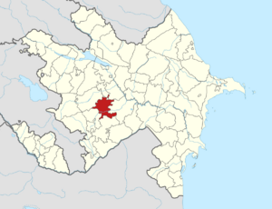
Map of Azerbaijan showing Aghdam District
|
|
| Country | |
| Region | Karabakh |
| Established | 8 August 1930 |
| Capital | Aghdam |
| Settlements | 138 |
| Area | |
| • Total | 1,150 km2 (440 sq mi) |
| Population
(2020)
|
|
| • Total | 204,000 |
| • Density | 177.4/km2 (459.4/sq mi) |
| Time zone | UTC+4 (AZT) |
| Postal code |
0200
|
The Aghdam District (called Ağdam rayonu in Azerbaijani) is one of the 66 main areas in Azerbaijan. It is located in the western part of the country. This district is part of the Karabakh Economic Region.
Aghdam District shares borders with several other districts. These include Khojaly, Kalbajar, Tartar, Khojavend, Aghjabadi, and Barda. The official capital of the district is Aghdam. However, for now, the actual working capital is Quzanlı. In 2020, about 204,000 people lived in the district.
Most of the Aghdam District was taken over by Armenian forces in the early 1990s. This happened during the First Nagorno-Karabakh War. But after the 2020 Nagorno-Karabakh ceasefire agreement, things changed. The city of Aghdam and the areas around it were given back to Azerbaijan. This happened on November 20, 2020.
History of Aghdam District
People have different ideas about where the name "Aghdam" comes from. Some believe "Ağdam" means "white castle" in an old Turkic language. They say that Turkic tribes long ago built small forts here for protection. Over time, the meaning of the name changed.
In the mid-1700s, a leader named Panahali Khan built a white stone building in this city. This building became very important to the people living nearby. So, "Aghdam" also came to mean a "white house" that shines in the sun.
Aghdam was founded in the middle of the 18th century. It was where Panahali Khan Javanshir had his summer palace. His family also had a burial ground there. In 1828, Aghdam became a city. During the time of the Soviet Union, Aghdam was an important industrial center. It had factories that made butter, wine, brandy, and silk. There were also factories for tools and hardware. The city had an airport and two train stations. For education, Aghdam offered technical, agricultural, medical, and music schools.
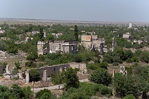
On July 23, 1993, the city was taken over by the Artsakh Defense Army with help from the Armenian Armed Forces. The city was completely destroyed. Its people had to leave and move to other parts of Azerbaijan.
After this, Aghdam became like a ghost town. It was located in a special area between the Armenian and Azerbaijani forces. The city is about 365 kilometers (227 miles) away from Baku, the capital of Azerbaijan. According to a peace agreement signed on November 10, 2020, the entire Aghdam District returned to Azerbaijan's control on November 20, 2020. In 2008, the city of Aghdam had about 39,900 people.
Population Changes
In 1979, about 108,554 people lived in the Aghdam District. By 1989, this number grew to 131,293. About 28,000 of these people lived in Aghdam city itself. The rest, over 103,000 people, lived in the villages and other rural areas.
After the Battle of Aghdam, all Azerbaijani residents in the occupied areas had to leave their homes. They became refugees. According to a census in Azerbaijan in 2009, the district's population was around 175,400 people.
People Who Moved Home
Many people from the Nagorno-Karabakh region and nearby areas had to leave their homes. These people are called internally displaced people. They used to live in temporary tent settlements across the country. Now, the government has built new houses for them in the Aghdam district.
See also
 In Spanish: Raión de Agdam para niños

