Agulo facts for kids
Quick facts for kids
Agulo
|
|||
|---|---|---|---|

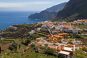
View of Agulo
|
|||
|
|||

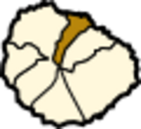
Location in La Gomera
|
|||
| Country | |||
| Autonomous community | Canary Islands | ||
| Province | Santa Cruz de Tenerife | ||
| Island | La Gomera | ||
| Area | |||
| • Total | 25.39 km2 (9.80 sq mi) | ||
| Elevation | 215 m (705 ft) | ||
| Population
(2018)
|
|||
| • Total | 1,067 | ||
| • Density | 42.024/km2 (108.84/sq mi) | ||
| Demonym(s) | Agulenses | ||
Agulo is a small, beautiful town located on the northern coast of La Gomera. This island is one of the amazing Canary Islands of Spain. Agulo is part of the province of Santa Cruz de Tenerife.
The town is about 13 kilometers (8 miles) northwest of San Sebastián de la Gomera. This is the capital city of La Gomera. In 2018, about 1,067 people lived in Agulo. People from Agulo are called Agulenses.
Contents
Discover Agulo's Green Beauty
Agulo is often called the "green balcony" of La Gomera. This is because it has many green areas and offers amazing views. It is a great place to explore nature.
Exploring the Meriga Forest
A special part of Agulo is the Meriga Forest. This forest is part of the Garajonay National Park. The park is so important that UNESCO has made it a World Heritage Site. This means it is a place that is very special to the whole world.
What Grows in Agulo?
The main crop grown in Agulo is bananas. Farmers here work hard to grow these tasty fruits. You might see many banana plantations around the area.
Parts of Agulo
Agulo is made up of several smaller areas or villages. Each one has its own unique charm. These areas include:
- Agulo
- Lepe
- La Palmita
- Las Rosas
- Cruz de Tierno
- Juego de Bolas
- Meriga
- Pajar de Bento
- Piedra Gorda
- Serpa
- La Vega
Images for kids
See also
 In Spanish: Agulo para niños
 | Valerie Thomas |
 | Frederick McKinley Jones |
 | George Edward Alcorn Jr. |
 | Thomas Mensah |


