Ahipara facts for kids
Quick facts for kids
Ahipara
|
|
|---|---|

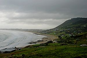
Ahipara Bay with Whangatauatia Maunga to the right
|
|
| Country | New Zealand |
| Region | Northland Region |
| District | Far North District |
| Ward | Te Hiku |
| Community | Te Hiku |
| Subdivision | Kaitāia |
| Electorates |
|
| Area | |
| • Total | 4.53 km2 (1.75 sq mi) |
| Population
(June 2023)
|
|
| • Total | 1,450 |
| • Density | 320.1/km2 (829/sq mi) |
| Postcode |
0481
|
Ahipara is a small town in the Northland Region of New Zealand. It sits at the very southern end of the famous Ninety Mile Beach. To its west is the Tauroa Peninsula, and to its east is the Herekino Forest. Ahipara Bay is found to the northwest. The larger town of Kaitaia is about 14 kilometers (9 miles) to the northeast.
Contents
History of Ahipara
Early History and Name
The name Ahipara comes from the Māori language. Ahi means "fire," and para is a type of large fern. So, Ahipara means "a fire where para was cooked." Before the late 1700s, the area was known as Wharo. This name means "stretched out." It came from a story where a chief named Tohe asked a slave to measure how far the tide had gone out by using arm-spans.
Kauri Gum Industry
In the late 1800s and early 1900s, Ahipara was a busy place for kauri gum diggers. Kauri gum is a fossilized resin from kauri trees, used for things like varnish. Digging for this gum was very popular here, especially in the 1920s and 1930s. Ahipara was one of the last places in New Zealand where kauri gum was dug on a large scale. Today, you can visit the Ahipara Gumfields Historic Reserve south of the town.
Shipwreck Bay and Toheroa
Shipwreck Bay, also called Te Kōhanga in Māori, is located at the southern tip of Ahipara Bay. At low tide, you can often see parts of old shipwrecks there. Ahipara Bay was also once famous for its toheroa shellfish. However, these shellfish are now very rare, so gathering them is restricted to help them recover.
Recent Events
In recent years, Ahipara has experienced some large fires. In February 2019, a fire near Shipwreck Bay caused six homes to be evacuated. Another fire in October 2020 near the southern end of Ninety Mile Beach led to four homes being evacuated.
People of Ahipara
Ahipara covers an area of about 4.53 square kilometers (1.75 sq mi). In 2023, about 1,272 people lived there. The population has grown by about 3.4% since 2018.
| Historical population | ||
|---|---|---|
| Year | Pop. | ±% p.a. |
| 2006 | 1,095 | — |
| 2013 | 1,032 | −0.84% |
| 2018 | 1,230 | +3.57% |
| 2023 | 1,272 | +0.67% |
The average age of people in Ahipara is about 45.2 years. About 20% of the population is under 15 years old. Most people in Ahipara identify as European (Pākehā) or Māori. Many people identify with both groups. English is spoken by almost everyone, and about 18% of people also speak the Māori language.
Māori Culture and Marae

Ahipara is located within the traditional area, or rohe, of the Te Rarawa iwi (tribe). The town has strong connections to this iwi.
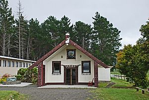
Ahipara is home to three important marae (meeting grounds) that are connected to Te Rarawa hapū (sub-tribes):
- Korou Kore Marae: This marae is linked to the Ngāti Moroki hapū. Its main meeting house, called a whare tūpuna, is also named Ngāti Moroki.
- Roma Marae: This marae is connected to four hapū: Ngāti Pākahi, Ngāti Waiora, Parewhero, and Te Patukirikiri. Its whare tūpuna is called Te Ōhākī. In 2020, the New Zealand Government helped fund upgrades for Roma Marae and other marae in the Te Rarawa area.
- Wainui Marae: Also known as Ngāti Moetonga Marae, this marae is linked to the Ngāti Moetonga and Te Rokeka hapū. Its whare tūpuna is also named Ngāti Moetonga.
Fun Things to Do
Ahipara and Shipwreck Bays are very popular places for surfing. Shipwreck Bay is known as one of the best "left-hand surf breaks" in the world. This means the waves break to the left from a surfer's perspective. The area was even featured in the famous 1966 surf movie The Endless Summer.
Ahipara is also part of Te Araroa, a long walking trail that goes all the way through New Zealand.
Schools in Ahipara
Ahipara School is a primary school for students in years 1 to 8 (ages 5-13). It has about 227 students. The school first opened in 1872 as a mission school and moved to its current location in 1901.
There is also an early childhood center called Ahipara Sandhoppers Early Childhood Centre. It has been operating on the school grounds since the mid-1990s and is known for its environmental efforts.
Protecting the Environment
Ahipara has several groups dedicated to looking after its coast. The Ahipara Komiti Takutaimoana works to ensure the sustainable use and protection of Kaimoana (seafood). The Ahipara Community CoastCare group focuses on protecting and restoring the sand dune environment along the coast.
 | Madam C. J. Walker |
 | Janet Emerson Bashen |
 | Annie Turnbo Malone |
 | Maggie L. Walker |


