Herekino facts for kids
Quick facts for kids
Herekino
|
|
|---|---|

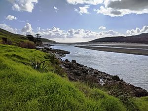
Herekino Harbour near Owhata
|
|
| Country | New Zealand |
| Region | Northland Region |
| District | Far North District |
| Ward | Te Hiku |
| Community | Te Hiku |
| Subdivision | Kaitāia |
| Electorates |
|
| Area | |
| • Total | 11.47 km2 (4.43 sq mi) |
| Population
(2023)
|
|
| • Total | 114 |
| • Density | 9.94/km2 (25.74/sq mi) |
Herekino is a small place in Northland, New Zealand. It is about 26 kilometers (16 miles) southwest of Kaitaia. The Herekino Harbour is an inlet from the Tasman Sea. It is also called the Herekino River.
To the north of Herekino is the Herekino Forest. This forest has many large kauri trees. The Tauroa Peninsula is located to the northwest. The harbour is mostly covered by water at high tide. It has a shallow entrance channel. The upper parts of the harbour are home to a mangrove forest.
The main town of Herekino is at the northeast end of the harbour. A small settlement called Owhata is on the rocky south shore. Owhata is a flat, grassy area with a shallow beach. It does not have much natural shelter. Also, fresh water can be limited there in summer.
Contents
People and Population
This section tells us about the people who live in Herekino and the nearby area.
Herekino and Owhata Population
The area that includes Herekino and Owhata is about 11.48 square kilometers. In the 2023 New Zealand census, 114 people lived here. This was a good increase from previous years. The population grew by 30 people (35.7%) since 2018. It grew by 18 people (18.8%) since 2013.
| Historical population for Herekino and Owhata | ||
|---|---|---|
| Year | Pop. | ±% p.a. |
| 2006 | 111 | — |
| 2013 | 96 | −2.05% |
| 2018 | 84 | −2.64% |
| 2023 | 114 | +6.30% |
There were 60 males and 54 females living in 39 homes. The average age was 45.2 years. About 18% of the people were under 15 years old. Another 18% were aged 15 to 29. Most people, 42%, were aged 30 to 64. About 18% were 65 or older.
People in Herekino come from different backgrounds. About 39.5% were European (Pākehā). A large number, 78.9%, were Māori. Some people also identified as Pasifika or other groups. Most people spoke English (94.7%). About 28.9% also spoke the Māori language.
Many people (44.7%) said they were Christian. About 36.8% said they had no religion.
Wider Herekino-Takahue Area
The larger Herekino-Takahue area is much bigger, covering 303.89 square kilometers. This area also includes Whangape Harbour and Takahue. As of 2023, it had an estimated population of 1,110.
| Historical population for Herekino-Takahue statistical area | ||
|---|---|---|
| Year | Pop. | ±% p.a. |
| 2006 | 966 | — |
| 2013 | 927 | −0.59% |
| 2018 | 963 | +0.76% |
| 2023 | 1,140 | +3.43% |
In the 2023 census, 1,140 people lived in this wider area. This was an increase of 177 people (18.4%) since 2018. The average age was 44.6 years.
In this larger area, 63.4% of people were European. About 57.4% were Māori. Other groups included Pasifika and Asian. Most people spoke English (97.4%). About 17.6% also spoke the Māori language.
Many people (37.4%) were Christian. About 45.8% said they had no religion.
History and Culture
Herekino has a rich history, going back to before Europeans arrived in New Zealand.
Early Māori History
The name Herekino comes from the Māori chief Tohe. He was visiting another chief, Taunaha, at Owhata. Tohe saw a bird trap that was tied incorrectly. He named the area Herekino-a-Taunaha, meaning "the false knot of Taunaha."
The Ngāti Ruānui tribe (now Te Aupōuri) were very important in the Herekino and Whangape harbours. They fought battles with other tribes in the area before European settlers arrived.
European Settlement and Changes
In 1846, a ship called the H.M.S. Osprey made a mistake. Due to misty weather, it thought Herekino Heads was the entrance to the Hokianga harbour. The ship ran aground on a shallow sand bank. Luckily, no one died. You can still see parts of the wreckage today. Because of this event, Herekino was sometimes called "False Hokianga" on old maps.
People from Dalmatia (a region in Croatia) started growing grapes in Herekino in the late 1890s. By 1906, there were 14 vineyards!
In the mid-1960s, Herekino was a small town with shops. It had a butcher and a petrol station. But when State Highway 1 was sealed (paved) through the Mangamuka Gorge to Kaitaia, the town quickly became smaller. People could travel more easily to bigger towns.
Marae (Meeting Places)
Herekino has two marae. These are special meeting places for Māori people. They are connected to the Ngāti Kurī and Te Aupōuri tribes of Te Rarawa.
- Rangikohu Marae has a meeting house called Ruia te Aroha.
- Manukau Marae has a meeting house called Whakamaharatanga.
In October 2020, the New Zealand Government gave money to upgrade these two marae. This project also helped 7 other Te Rarawa marae. It created 100 jobs for people in the area.
Education
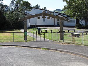
Herekino School is a local school for children from Year 1 to Year 8 (ages 5-13).
As of February 2024, the school has 29 students. The school first opened in 1888. Sadly, the first school building burned down in 1909. Its replacement also burned down in 1944.
 | Delilah Pierce |
 | Gordon Parks |
 | Augusta Savage |
 | Charles Ethan Porter |


