Alabaster, Alabama facts for kids
Quick facts for kids
Alabaster, Alabama
|
|||
|---|---|---|---|

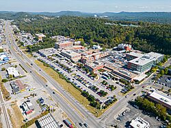
Aerial view of Highway 31 in Alabaster, AL
|
|||
|
|||

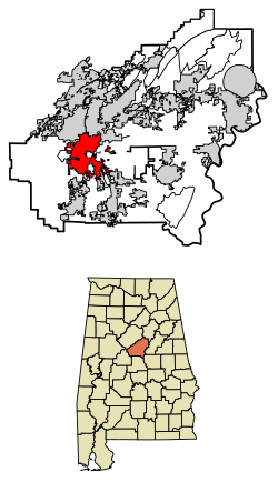
Location of Alabaster in Shelby County, Alabama.
|
|||
| Country | United States | ||
| State | Alabama | ||
| County | Shelby | ||
| Established | February 23, 1953 | ||
| Area | |||
| • Total | 25.59 sq mi (66.29 km2) | ||
| • Land | 25.28 sq mi (65.47 km2) | ||
| • Water | 0.31 sq mi (0.81 km2) | ||
| Elevation | 584 ft (178 m) | ||
| Population
(2020)
|
|||
| • Total | 33,284 | ||
| Time zone | UTC-6 (Central (CST)) | ||
| • Summer (DST) | UTC-5 (CDT) | ||
| ZIP code |
35007, 35114
|
||
| Area codes | 205, 659 | ||
| FIPS code | 01-00820 | ||
| GNIS feature ID | 2403069 | ||
| Website | Official website: http://www.cityofalabaster.com/ | ||
Alabaster is a city in Shelby County, Alabama, United States. It's located just south of Birmingham. In 2020, about 33,284 people lived there, making it one of Alabama's larger cities.
Contents
History of Alabaster
Alabaster got its name from a white mineral called "calcium carbonate." A man named George L. Scott Sr. owned a company that mined this mineral. The place where he shipped it was known as "Scott Rock."
Later, homes were built for the mine workers. In 1952, the first bank opened. George L. Scott Jr., who ran the bank, later became Alabaster's first mayor. The city officially became a city on February 23, 1953. At that time, 427 people lived there.
In recent years, Alabaster has been growing. In 2015, the city started planning to expand an area known for medical facilities. These plans also included building a civic center and new shops. In 2017, there were plans for a large shopping complex called District 31.
Geography and Location
Alabaster is located at 33°13′52″N 86°49′26″W / 33.23111°N 86.82389°W. The city is mostly in two valleys, the Cahaba and Opossum valleys. These valleys are separated by a ridge called Pine Ridge.
The valleys are surrounded by mountain ridges. Small creeks like Buck Creek flow into the Cahaba River. You can reach Alabaster using U.S. Route 31 or I-65 (exit 238). Birmingham is about 23 miles north, and Montgomery is about 69 miles south.
The city covers about 25.6 square miles. Most of this area is land, with a small part being water.
Alabaster's Climate
Alabaster has a humid subtropical climate. This means it usually has hot, humid summers and mild winters. It gets a good amount of rain throughout the year.
| Climate data for Alabaster, Alabama (Shelby County Airport), 1991–2020 normals, extremes 1995–present | |||||||||||||
|---|---|---|---|---|---|---|---|---|---|---|---|---|---|
| Month | Jan | Feb | Mar | Apr | May | Jun | Jul | Aug | Sep | Oct | Nov | Dec | Year |
| Record high °F (°C) | 80 (27) |
82 (28) |
87 (31) |
90 (32) |
96 (36) |
105 (41) |
104 (40) |
105 (41) |
101 (38) |
101 (38) |
89 (32) |
81 (27) |
105 (41) |
| Mean maximum °F (°C) | 72.7 (22.6) |
76.1 (24.5) |
82.2 (27.9) |
86.1 (30.1) |
91.6 (33.1) |
95.7 (35.4) |
96.5 (35.8) |
97.1 (36.2) |
93.9 (34.4) |
88.5 (31.4) |
77.9 (25.5) |
74.9 (23.8) |
98.6 (37.0) |
| Mean daily maximum °F (°C) | 55.7 (13.2) |
60.5 (15.8) |
67.9 (19.9) |
75.4 (24.1) |
82.5 (28.1) |
88.3 (31.3) |
91.1 (32.8) |
90.8 (32.7) |
86.1 (30.1) |
76.3 (24.6) |
66.0 (18.9) |
58.0 (14.4) |
74.9 (23.8) |
| Daily mean °F (°C) | 45.7 (7.6) |
49.9 (9.9) |
57.0 (13.9) |
64.0 (17.8) |
71.8 (22.1) |
78.5 (25.8) |
81.3 (27.4) |
80.9 (27.2) |
75.8 (24.3) |
65.1 (18.4) |
54.6 (12.6) |
48.2 (9.0) |
64.4 (18.0) |
| Mean daily minimum °F (°C) | 35.6 (2.0) |
39.3 (4.1) |
46.0 (7.8) |
52.6 (11.4) |
61.0 (16.1) |
68.7 (20.4) |
71.6 (22.0) |
71.0 (21.7) |
65.5 (18.6) |
53.9 (12.2) |
43.1 (6.2) |
38.3 (3.5) |
53.9 (12.2) |
| Mean minimum °F (°C) | 18.3 (−7.6) |
24.2 (−4.3) |
29.7 (−1.3) |
38.3 (3.5) |
47.9 (8.8) |
61.3 (16.3) |
65.0 (18.3) |
64.4 (18.0) |
53.5 (11.9) |
37.3 (2.9) |
26.9 (−2.8) |
24.3 (−4.3) |
17.2 (−8.2) |
| Record low °F (°C) | 9 (−13) |
4 (−16) |
14 (−10) |
28 (−2) |
37 (3) |
49 (9) |
56 (13) |
55 (13) |
42 (6) |
31 (−1) |
21 (−6) |
10 (−12) |
4 (−16) |
| Average precipitation inches (mm) | 5.35 (136) |
5.76 (146) |
5.40 (137) |
5.07 (129) |
4.15 (105) |
4.58 (116) |
4.93 (125) |
4.72 (120) |
3.57 (91) |
3.03 (77) |
4.56 (116) |
5.07 (129) |
56.19 (1,427) |
| Average snowfall inches (cm) | 0.1 (0.25) |
0.2 (0.51) |
0.1 (0.25) |
0.0 (0.0) |
0.0 (0.0) |
0.0 (0.0) |
0.0 (0.0) |
0.0 (0.0) |
0.0 (0.0) |
0.0 (0.0) |
0.0 (0.0) |
0.3 (0.76) |
0.7 (1.77) |
| Average precipitation days (≥ 0.01 in) | 10.8 | 11.4 | 11.5 | 9.7 | 9.9 | 11.5 | 12.8 | 11.5 | 8.0 | 8.2 | 9.0 | 11.3 | 125.6 |
| Average snowy days (≥ 0.1 in) | 0.2 | 0.2 | 0.1 | 0.0 | 0.0 | 0.0 | 0.0 | 0.0 | 0.0 | 0.0 | 0.0 | 0.1 | 0.6 |
| Source 1: NOAA | |||||||||||||
| Source 2: National Weather Service (mean maxima/minima, snow/snow days 2006–2020) | |||||||||||||
Population and People
Alabaster has grown a lot since it became a city. In 1960, there were only 1,623 people. By 2020, the population had grown to 33,284.
| Historical population | |||
|---|---|---|---|
| Census | Pop. | %± | |
| 1960 | 1,623 | — | |
| 1970 | 2,642 | 62.8% | |
| 1980 | 7,079 | 167.9% | |
| 1990 | 14,732 | 108.1% | |
| 2000 | 22,619 | 53.5% | |
| 2010 | 30,352 | 34.2% | |
| 2020 | 33,284 | 9.7% | |
| U.S. Decennial Census | |||
What the 2010 Census Showed
In 2010, there were over 30,000 people living in Alabaster. The city had about 11,016 households. Many families lived there, with 68% being married couples. About 42% of households had children under 18.
The population was quite diverse. Most residents were White (81.2%), and 15% were Black or African American. About 4.5% of the population identified as Hispanic or Latino. The average age in the city was 35 years old.
Alabaster's Population in 2020
The 2020 census showed continued growth in Alabaster. The total population reached 33,284 people. There were 11,568 households in the city.
The racial makeup in 2020 was:
| Race | Num. | Perc. |
|---|---|---|
| White | 21,791 | 65.47% |
| Black or African American | 5,300 | 15.92% |
| Native American | 63 | 0.19% |
| Asian | 394 | 1.18% |
| Pacific Islander | 20 | 0.06% |
| Other/Mixed | 1,500 | 4.51% |
| Hispanic or Latino | 4,216 | 12.67% |
Alabaster-Helena Census Division
The Alabaster-Helena Census Division was created in 1980. It combines several areas, including parts of Alabaster and nearby cities like Helena and Pelham. This division helps track population changes in a larger region.
| Historical population | |||
|---|---|---|---|
| Census | Pop. | %± | |
| 1980 | 33,674 | — | |
| 1990 | 59,090 | 75.5% | |
| 2000 | 86,781 | 46.9% | |
| 2010 | 118,831 | 36.9% | |
| U.S. Decennial Census | |||
City Council Members
The City Council helps run the city of Alabaster. Each member represents a different district. They make important decisions for the community.
| District | Name | Position |
|---|---|---|
| 1 | Mrs. Sophie Martin | President |
| 2 | Mr. Rick Ellis | Councilperson |
| 3 | Mrs. Stacy Rakestraw | Councilperson |
| 4 | Mr. Greg Farrell | President Pro-Temp |
| 5 | Mr. Jamie Cole | Councilperson |
| 6 | Zach Zahariadis | Councilperson |
| 7 | Ms. Kerri Bell-Pate | Councilperson |
Schools in Alabaster
Alabaster has its own school system, called the Alabaster City Schools System. It started on July 1, 2013. Before that, the schools were part of the Shelby County system.
Here are some of the public schools in Alabaster:
- Creek View Elementary School
- Meadow View Elementary School
- Thompson Intermediate School
- Thompson Middle School
- Thompson High School
There are also private schools, like Evangel Christian School.
Transportation Options
ClasTran offers a "dial-a-ride" service in Alabaster. This means you can call to arrange a ride on weekdays.
See also
 In Spanish: Alabaster para niños
 | William M. Jackson |
 | Juan E. Gilbert |
 | Neil deGrasse Tyson |


