
Alambique Creek facts for kids
Quick facts for kids Alambique Creek |
|
|---|---|

Location of the mouth in California
|
|
| Country | United States |
| State | California |
| Region | Southeastern San Mateo County |
| City | Woodside, California |
| Physical characteristics | |
| Main source | Wunderlich County Park 1,930 ft (590 m) 37°24′03″N 122°17′20″W / 37.40083°N 122.28889°W |
| River mouth | Sausal Creek Just above Searsville Lake 371 ft (113 m) 37°24′12″N 122°14′52″W / 37.40333°N 122.24778°W |
Alambique Creek, also known as Arroyo Alembique, is a stream about 2.7 miles (4.3 kilometers) long. It is located in San Mateo County, California, in the United States. This creek is an important part of the San Francisquito Creek watershed, which is a system of rivers and streams that drain into a larger body of water.
History of Alambique Creek


The name "Alambique" comes from the Spanish language word for "still." A still is a special device used to make certain liquids, like some types of drinks. In the 1800s, the name was often spelled alembique. The English word for this device is alembic.
The creek's name is linked to two men, Tom Bowen and Nicholas Dawson. In 1842, they built a still on the creek. Later, in 1904, the creek was used by J. A. Folger. He created the first hydro-electrical power system in the area here. This system used the power of flowing water to make electricity.
Where Alambique Creek Flows
Alambique Creek starts below Skyline Boulevard. This is near the intersection of Bear Gulch Road and Bear Glen Drive.
The creek then flows across La Honda Road. Just south of where Mountain Home Road and Portola Road meet, the creek enters an old wetland pond. This pond is now held back by the road-fill of Portola Road and a pipe called a culvert.
After this, Alambique Creek flows under Portola Road. It then joins Sausal Creek just before entering the upper part of Searsville Reservoir.
Wildlife and Nature
Alambique Creek was once a place where steelhead trout (a type of rainbow trout) would lay their eggs. These fish are also known as coastal rainbow trout (Oncorhynchus mykiss irideus).
In 1981, scientists studied the fish in the creek. They found two rainbow trout that live in the stream. These fish had been separated from the San Francisco Bay by Searsville Dam.
However, in May 2002, a problem was found. A culvert, which is a tunnel under Highway 84, was blocking the fish. It was impossible for the fish to swim upstream past this barrier. This means they could not reach their old spawning areas.
Images for kids
-
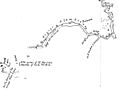
A map from 1857 showing Rancho El Corte de Madera and the creek
-
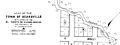
The creek flowed through the old village of Searsville
