Algarrobo, Yauco, Puerto Rico facts for kids
Quick facts for kids
Algarrobo
|
|
|---|---|
|
Barrio
|
|

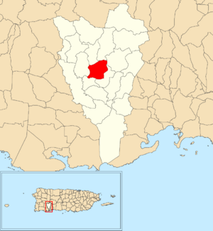
Location of Algarrobo within the municipality of Yauco shown in red
|
|
| Commonwealth | |
| Municipality | |
| Area | |
| • Total | 2.25 sq mi (5.8 km2) |
| • Land | 2.20 sq mi (5.7 km2) |
| • Water | 0.05 sq mi (0.1 km2) |
| Elevation | 515 ft (157 m) |
| Population
(2010)
|
|
| • Total | 419 |
| • Density | 190.5/sq mi (73.6/km2) |
| Source: 2010 Census | |
| Time zone | UTC−4 (AST) |
Algarrobo is a small community, also known as a barrio, located in the municipality of Yauco, Puerto Rico. In 2010, about 419 people lived there. It is a part of the beautiful island of Puerto Rico, which is a commonwealth of the United States.
A Look Back in Time
Puerto Rico used to belong to Spain. After the Spanish–American War in 1898, Spain gave Puerto Rico to the United States. This made Puerto Rico an unincorporated territory of the U.S.
In 1899, the United States government did a count of all the people in Puerto Rico. They found that 952 people lived in the Algarrobo barrio at that time.
Where is Algarrobo?
Algarrobo barrio is located in the middle part of Yauco. It sits within the Cordillera Central, which is a mountain range.
The Yauco River flows through this area. This river starts from Lake Luchetti in the north. It then travels south towards the main part of Yauco, known as downtown Yauco.
How Many People Live Here?
Counting people helps us understand how communities grow or change. This is called demographics.
Here's a look at how Algarrobo's population has changed over the years:
| Historical population | |||
|---|---|---|---|
| Census | Pop. | %± | |
| 1980 | 657 | — | |
| 1990 | 567 | −13.7% | |
| 2000 | 483 | −14.8% | |
| 2010 | 419 | −13.3% | |
| U.S. Decennial Census | |||
See also
 In Spanish: Algarrobo (Yauco) para niños
- List of communities in Puerto Rico
 | James Van Der Zee |
 | Alma Thomas |
 | Ellis Wilson |
 | Margaret Taylor-Burroughs |


