Ali Chuk, Arizona facts for kids
Quick facts for kids
Ali Chuk, Arizona
|
|
|---|---|
|
Populated place
|
|

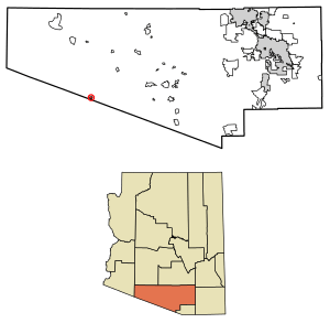
Location of Ali Chuk in Pima County, Arizona.
|
|
| Country | United States |
| State | Arizona |
| County | Pima |
| Area | |
| • Total | 1.44 sq mi (3.73 km2) |
| • Land | 1.44 sq mi (3.73 km2) |
| • Water | 0.00 sq mi (0.00 km2) |
| Elevation | 1,762 ft (537 m) |
| Population
(2010)
|
|
| • Total | 161 |
| • Estimate
(2016)
|
N/A |
| Time zone | UTC-7 (Mountain (MST)) |
| • Summer (DST) | UTC-7 (MST) |
| ZIP code |
85634
|
| Area code(s) | 520 |
| FIPS code | 025-01560 |
| GNIS feature ID | 2582723 |
Ali Chuk is a small community located in Pima County, Arizona, United States. It is a "census-designated place," which means it's an area identified by the U.S. Census Bureau for statistical purposes. It's not an official city or town.
In 2010, about 161 people lived in Ali Chuk. The community covers an area of about 1.44 square miles (3.73 square kilometers). It is located very close to the border with Mexico. Ali Chuk is about 1,762 feet (537 meters) above sea level. It's important not to confuse Ali Chuk with another nearby village called Ali Chukson, which is also on the Tohono O'odham Nation reservation.
Population Facts
| Historical population | |||
|---|---|---|---|
| Census | Pop. | %± | |
| 2010 | 161 | — | |
| U.S. Decennial Census | |||
Ali Chuk was first listed as a census-designated place (CDP) in the 2010 U.S. Census. This means that for the first time, the U.S. Census Bureau collected specific population data for this area.
Schooling in Ali Chuk
Students living in Ali Chuk attend schools that are part of the Indian Oasis-Baboquivari Unified School District. This school district serves several communities in the area.
See also
 In Spanish: Ali Chuk para niños
 | Tommie Smith |
 | Simone Manuel |
 | Shani Davis |
 | Simone Biles |
 | Alice Coachman |


