Aliwal North facts for kids
Quick facts for kids
Maletswai
Aliwal North
|
|
|---|---|

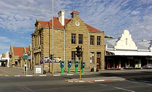
The old Post Office building constructed from sandstone.
|
|
| Country | South Africa |
| Province | Eastern Cape |
| District | Joe Gqabi |
| Municipality | Walter Sisulu |
| Government | |
| • Type | Municipal Council |
| Area | |
| • Total | 24.18 km2 (9.34 sq mi) |
| Elevation | 1,325 m (4,347 ft) |
| Population
(2011)
|
|
| • Total | 3,992 |
| • Density | 165.10/km2 (427.59/sq mi) |
| Racial makeup (2011) | |
| • Black African | 48.1% |
| • White | 43.74% |
| • Coloured | 5.66% |
| • Indian/Asian | 0.95% |
| • Other | 1.55% |
| First languages (2011) | |
| • Afrikaans | 40.31% |
| • Xhosa | 29.63% |
| • English | 7.16% |
| • Sotho | 5.39% |
| • Other | 17.51% |
| Time zone | UTC+2 (SAST) |
| Postal code (street) |
9750
|
| PO box |
9750
|
| Area code | 051 (−633- / -634-) |
Maletswai (once called Aliwal North) is a town located in the middle of South Africa. It sits right next to the Orange River in the Eastern Cape Province. This town is a busy place for business in the northern part of the Eastern Cape. An old church, the Dutch Reformed Church, was built here in 1855.
Contents
History of Maletswai
How Maletswai Was Founded
One of the first European settlers in this area was Pieter Jacobus de Wet. He built a house near Buffelsvlei around 1828. Later, in 1850, Sir Harry Smith officially started the town. He was the Governor of the Cape Colony (an old name for a part of South Africa) from 1847 to 1852.
Sir Harry Smith named the town "Aliwal North". He did this to remember his victory in a battle called the Battle of Aliwal. This battle happened in India in 1846 during the First Sikh War. The town's land was set up in 1849 and then sold in pieces.
Town Growth and Changes
The park in the middle of Maletswai, called Juana Square Gardens, is named after Sir Harry Smith's wife, Juana María de los Dolores de León. Maletswai became an official municipality (meaning it had its own local government) in 1882.
The railway line reached Maletswai on September 2, 1885, connecting it to Molteno. During the Second Boer War, a camp was set up in Aliwal North in 1901. This camp housed about 2,000 people who had to leave their homes. It closed by November 1902 when people could return home.
Education in Maletswai
Maletswai has many schools for young people to learn and grow. There are 10 primary schools and 6 high schools. The town also has a college for technical and vocational training.
Primary Schools
- Alheit van der Merwe Primary School
- Holy Cross Primary
- Flamingo Primary School
- Laerskool Aliwal-Noord
- Maletswai Primary School
- Nchafatso Primary School
- Nkosi Sikelela' Private Primary School
- Pelomosa Primary School
- Vulamazibuko Primary School
- Vumile Primary School
High Schools
- Malcomess Senior Secondary School
- Hoërskool Aliwal-Noord
- Bishop Demont High School
- Egqili Senior Secondary School
- Faith High School
- Joe Gqabi Secondary School
Geography of Maletswai
Location and Rivers
Maletswai's location was chosen because it has good water sources and hot springs. It also had a good place to cross the Orange River. This crossing point, or 'drift', is just below where the Orange River meets the Kraai River.
The Frere Bridge was built in 1880 to cross the river. Later, the General Hertzog Bridge replaced it on the N6 road. This road leads to Bloemfontein, which is about 206 kilometers north. To the southwest of the town, the Kramberg mountain rises to about 2,000 meters above sea level.
Town Suburbs
Maletswai has several neighborhoods, or suburbs. These include:
- Maletswai CBD (Central Business District)
- Arbor View
- Buffelsbaden
- Bird's Eye View
- Dukathole
- Hilton
- Joe Gqabi
- Area13
Layout and Connections
Town Areas
The main business area of Maletswai is surrounded by several suburbs. These include Dukathole, Hilton, Joe Gqabi, the Springs (where the famous Aliwal Spa is located), and Arborsig. Many people who live and work at the Goedemoed Correctional Services facility, which is across the Orange River, use the town's shops, hospital, churches, and schools.
Transport and Travel
The town is connected to nearby towns by a good system of roads. It is also a popular stop for tourists traveling to resorts in the Eastern Cape Drakensberg mountains. Although the railway station is now closed, the town has a good airfield. It has three grass runways that are safe to use during the day.
Notable People from Maletswai
Many interesting people have come from Maletswai, including:
- Joe Gqabi (1921-1981), an important activist for the African National Congress.
- Thamsanqa Kambule, a well-known South African mathematician and educator.
- Bongani Ndulula, a South African football player.
- François Steyn, a famous Springbok Rugby player.
- Wandisile Letlabika, another South African football player.
Tourism in Maletswai
Hot Mineral Springs
The main attractions in Maletswai are its two hot mineral springs. These springs have a very high amount of minerals and gases, which makes the water special.
The thermal springs resort, called Aliwal Spa, is located within the town. It was rebuilt between 2010 and 2014 and reopened to the public in 2015. It's a great place to relax and enjoy the warm, mineral-rich water.
Climate in Maletswai
Maletswai has a climate that is called a subtropical highland climate (Cwb). This means it has warm summers and cool, dry winters.
| Climate data for Aliwal North | |||||||||||||
|---|---|---|---|---|---|---|---|---|---|---|---|---|---|
| Month | Jan | Feb | Mar | Apr | May | Jun | Jul | Aug | Sep | Oct | Nov | Dec | Year |
| Mean daily maximum °C (°F) | 23 (73) |
21 (70) |
20 (68) |
18 (64) |
14 (57) |
12 (54) |
10 (50) |
11 (52) |
13 (55) |
16 (61) |
19 (66) |
21 (70) |
23 (73) |
| Daily mean °C (°F) | 21 (70) |
21 (70) |
18 (64) |
15 (59) |
10 (50) |
7 (45) |
7 (45) |
10 (50) |
13 (55) |
16 (61) |
18 (64) |
20 (68) |
14 (57) |
| Mean daily minimum °C (°F) | 11 (52) |
10 (50) |
7 (45) |
4 (39) |
2 (36) |
−2 (28) |
−3 (27) |
0 (32) |
1 (34) |
4 (39) |
6 (43) |
10 (50) |
12 (54) |
| Average precipitation mm (inches) | 76 (3.0) |
83 (3.3) |
83 (3.3) |
48 (1.9) |
27 (1.1) |
13 (0.5) |
11 (0.4) |
16 (0.6) |
23 (0.9) |
40 (1.6) |
54 (2.1) |
61 (2.4) |
535 (21.1) |
 | Kyle Baker |
 | Joseph Yoakum |
 | Laura Wheeler Waring |
 | Henry Ossawa Tanner |


