Alkali Ridge facts for kids
|
Alkali Ridge
|
|

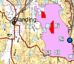
Extract from a BLM map of eastern Utah; the National Historic Landmark is shown in red
|
|
| Lua error in Module:Location_map at line 420: attempt to index field 'wikibase' (a nil value). | |
| Location | San Juan County, Utah, USA |
|---|---|
| Nearest city | Blanding, Utah |
| NRHP reference No. | 66000740 |
Quick facts for kids Significant dates |
|
| Added to NRHP | October 15, 1966 |
| Designated NHLD | July 19, 1964 |
Alkali Ridge, also known as Alkali Point, is a very important place in Utah, USA. It holds the ancient remains of the earliest Puebloan people. These remains show how these people started living in settled communities. They built multi-story homes and special round buildings called kivas.
Scientists have found amazing pottery here. These discoveries help us understand the Puebloan way of life. Alkali Ridge is so important that it helps define a major time period in Puebloan history.
Contents
Discovering Ancient Puebloan Life at Alkali Ridge
Alkali Ridge is not just one spot. It is many scattered archaeological sites. These sites are found in San Juan County, Utah. They give us clues about how the early Puebloan people lived. This area is like an open-air museum. It shows us how ancient communities grew and changed over time.
A Glimpse into Early Puebloan History
The ancient remains at Alkali Ridge are very old. They show us the earliest forms of Puebloan architecture. This means the first types of buildings these people made. Before this time, people often lived in scattered, simple pit-style dwellings. These were homes dug partly into the ground.
From Pit Dwellings to Settled Homes
Alkali Ridge shows a big change in how people lived. It marks a shift from a wandering lifestyle to a settled agricultural one. This means people started growing their own food. They no longer had to move around to find food. This change allowed them to build more permanent homes.
What Did They Build?
At Alkali Ridge, archaeologists have found remains of multi-story buildings. These were homes with more than one level. They also found kivas. Kivas are special round buildings. They were used for religious ceremonies and community gatherings. These structures show that the Puebloan people were skilled builders.
Amazing Discoveries at Alkali Ridge
The buildings and kivas at Alkali Ridge have given us many treasures. Scientists have found high-quality ceramics here. Ceramics are items made from clay, like pots and bowls. These pottery pieces are very well made. They tell us a lot about the art and daily life of the Puebloan people.
Understanding the Pueblo II Period
Alkali Ridge is known as the "type location" for the Pueblo II Period. This period lasted from about 900 CE to 1100 CE. A "type location" means that the discoveries at Alkali Ridge help define this entire time. The buildings and pottery found here are typical of this era. They help archaeologists understand other sites from the same period.
Alkali Ridge: A National Historic Landmark
Because of its great importance, Alkali Ridge was declared a National Historic Landmark in 1964. This means it is a place of national historical significance. It is protected to preserve its valuable archaeological findings. This status helps ensure that future generations can learn from this amazing site.
 | Selma Burke |
 | Pauline Powell Burns |
 | Frederick J. Brown |
 | Robert Blackburn |

