
Almshouse Branch (Isaac Branch tributary) facts for kids
Quick facts for kids Almshouse Branch |
|
|---|---|


Location of Almshouse Branch mouth
|
|
| Other name(s) | Tributary to Isaac Branch |
| Country | United States |
| State | Delaware |
| County | Kent |
| Physical characteristics | |
| Main source | divide between Almshouse Branch and Cow Marsh Ditch (Choptank River) about 3 miles southwest of Camden, Delaware 62 ft (19 m) 39°05′08″N 075°35′55″W / 39.08556°N 75.59861°W |
| River mouth | Isaac Branch about 2 miles west of Wyoming, Delaware 30 ft (9.1 m) 39°07′22″N 075°35′09″W / 39.12278°N 75.58583°W |
| Length | 3.16 mi (5.09 km) |
| Basin features | |
| Progression | north |
| River system | St. Jones River |
| Basin size | 2.29 square miles (5.9 km2) |
| Tributaries |
|
| Bridges | Thicket Road, Westville Road |
Almshouse Branch is a small stream, about 3.16 miles (5.09 kilometers) long, located in Kent County, Delaware. It's like a small helper stream, also known as a "first order tributary," that flows into a larger stream called Isaac Branch.
Where Does Almshouse Branch Flow?
Almshouse Branch starts its journey about 3 miles (4.8 km) southwest of a town called Camden in Kent County, Delaware. It begins in an area where the land divides water, near another stream known as Cow Marsh Ditch. From there, Almshouse Branch flows generally north. It eventually joins Isaac Branch about 2 miles (3.2 km) west of Wyoming, Delaware.
What is a Watershed?
A watershed is like a big bowl or area of land where all the rain and snowmelt drain into a common point, like a river, lake, or ocean. The Almshouse Branch watershed covers about 2.29 square miles (5.93 square kilometers). This area gets about 44.8 inches (113.8 cm) of rain each year. About 5% of this watershed is covered by forests.
Images for kids
-
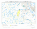
This map shows the path of Almshouse Branch and the area of land that drains into it.
.gif)
