
Isaac Branch (St. Jones River tributary) facts for kids
Quick facts for kids Isaac Branch |
|
|---|---|

Isaac Branch at Breaknock Park
|
|


Location of Isaac Branch mouth
|
|
| Other name(s) | Tributary to St. Jones River |
| Country | United States |
| State | Delaware |
| County | Kent |
| City | Dover Camden Wyoming |
| Physical characteristics | |
| Main source | divide between Isaac Branch and Cahoon Branch about 1 mile southeast of Pearsons Corner, Delaware 67 ft (20 m) 39°08′26″N 075°38′28″W / 39.14056°N 75.64111°W |
| River mouth | St. Jones River Dover, Delaware 0 ft (0 m) 39°07′45″N 075°30′08″W / 39.12917°N 75.50222°W |
| Length | 10.13 mi (16.30 km) |
| Basin features | |
| Progression | east |
| River system | St. Jones River |
| Basin size | 14.82 square miles (38.4 km2) |
| Tributaries |
|
| Waterbodies | Wyoming Lake Moores Lake |
| Bridges | Hazlettville Road, Quail Run, Todds Mill Road, Wyoming Mill Road, US 13, S. State Street |
Isaac Branch is a stream, or small river, located in Kent County, Delaware. It flows for about 10 miles (16 kilometers). Isaac Branch is a "tributary," which means it flows into a larger river called the St. Jones River.
Where Isaac Branch Begins and Ends
Isaac Branch starts about 1 mile (1.6 kilometers) southeast of a place called Pearsons Corner in Kent County, Delaware. This is where the land divides the water flow between Isaac Branch and another stream called Cahoon Branch. From there, Isaac Branch flows generally towards the east. It eventually joins the St. Jones River in the city of Dover, Delaware.
Understanding the Isaac Branch Watershed
A "watershed" is an area of land where all the water drains into a single river, lake, or ocean. The Isaac Branch watershed covers about 14.82 square miles (38.4 square kilometers). This area gets about 44.8 inches (114 centimeters) of rain each year. About 6% of the land in this watershed is covered by forests.
Images for kids
-
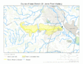
This map shows the path of Isaac Branch.
-
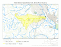
This map shows the entire watershed area of Isaac Branch.
.gif)
.gif)
