Altamura Island facts for kids
|
Native name:
Isla Altamura (or Isla de Altamura)
|
|
|---|---|
| Geography | |
| Location | Pacific Ocean |
| Coordinates | 24°53′00″N 108°08′00″W / 24.883333°N 108.133333°W |
| Adjacent bodies of water | Ocean |
| Area | 101.17 km2 (39.06 sq mi) |
| Administration | |
Altamura Island (also called Isla Altamura in Spanish) is a cool island located in Mexico. You can find it in the Gulf of California, which is part of the Pacific Ocean. This island is special because it's one of the largest private islands in the world!
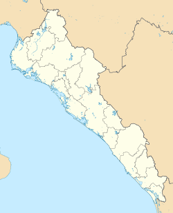
Altamura Island is found on the west coast of the Sinaloa state in Mexico. It's about 70 kilometers (43 miles) west of a city called Culiacán. The island is quite big, covering an area of 101.17 square kilometers (39.06 square miles). It stretches for about 40 kilometers (25 miles) in length. Its width changes, from about 900 meters (0.56 miles) to 3.7 kilometers (2.3 miles).
What Makes Altamura Island Special?
Altamura Island is known as a barrier island. This means it's a long, narrow island that runs parallel to the coastline. It helps protect the mainland from strong ocean waves and storms.
Island Features
The island has beautiful open beaches where you can see lots of sand. It also has very large sand dunes, especially in the northwestern part. These are big hills made of sand, shaped by the wind.
In the southern part of the island, you'll find intertidal zones. These are areas along the coast that are sometimes covered by ocean water during high tide and sometimes exposed to the air during low tide. These zones are made up of different materials like silt, clay, sand, and gravel.
Home to Amazing Wildlife
Altamura Island is part of a larger natural area called the bahía de Santa María complex. This area is very important for nature and is home to many different kinds of animals.
- Marine Life: The waters around the island are full of diverse marine life. This means you can find many types of fish, crabs, and other sea creatures living there.
- Migratory Birds: Many migratory birds visit Altamura Island. These are birds that travel long distances between their breeding grounds and their winter homes. The island provides a safe place for them to rest and find food.
- Whales: If you're lucky, you might even spot whales near Altamura Island! These giant ocean mammals are a truly amazing sight.
Altamura Island is a fantastic example of a natural habitat that supports a wide variety of plants and animals.
See also
 In Spanish: Isla Altamura para niños


