Andalgalá facts for kids
Quick facts for kids
Ciudad de Andalgalá
|
|
|---|---|

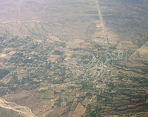
Aerial view
|
|
| Country | |
| Province | |
| Department | Andalgalá |
| Elevation | 960 m (3,150 ft) |
| Population | |
| • Total | 14,068 |
| Time zone | UTC−3 (ART) |
| CPA base |
K4740
|
| Dialing code | +54 3835 |
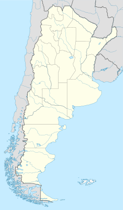
Andalgalá is a city in the Catamarca province of Argentina. It sits in a valley close to the Sierra de Aconquija mountains. About 14,000 people lived there in 2001. Andalgalá is the main town of its department. It is about 260 kilometers from the provincial capital, San Fernando del Valle de Catamarca.
The Andalgalá River flows nearby. This river helps power a hydroelectric plant. This plant uses water to create electricity for the area.
Andalgalá was first built as a fort on July 12, 1658. It became a city much later, in 1952. Its name comes from the Quechua language. It can mean "Lord of the Hare" or "Lord of the High Mountain."
Climate in Andalgalá
Andalgalá has a very dry and hot climate. It is known as a hot arid climate, or BWh on climate maps. This means it gets very little rain.
Most of the rain falls between November and March. About 80% of the yearly rain happens in these months. The rest of the year is usually very dry.
| Climate data for Andalgalá (1901–1960) | |||||||||||||
|---|---|---|---|---|---|---|---|---|---|---|---|---|---|
| Month | Jan | Feb | Mar | Apr | May | Jun | Jul | Aug | Sep | Oct | Nov | Dec | Year |
| Record high °C (°F) | 43.4 (110.1) |
43.1 (109.6) |
39.9 (103.8) |
38.7 (101.7) |
36.3 (97.3) |
35.3 (95.5) |
37.2 (99.0) |
39.3 (102.7) |
39.9 (103.8) |
42.2 (108.0) |
41.9 (107.4) |
43.3 (109.9) |
43.4 (110.1) |
| Mean daily maximum °C (°F) | 33.7 (92.7) |
32.3 (90.1) |
30.1 (86.2) |
26.2 (79.2) |
21.7 (71.1) |
18.3 (64.9) |
18.7 (65.7) |
21.5 (70.7) |
25.5 (77.9) |
28.9 (84.0) |
31.9 (89.4) |
33.7 (92.7) |
26.9 (80.4) |
| Daily mean °C (°F) | 25.1 (77.2) |
24.0 (75.2) |
21.9 (71.4) |
17.9 (64.2) |
13.7 (56.7) |
9.9 (49.8) |
10.0 (50.0) |
12.7 (54.9) |
16.7 (62.1) |
20.1 (68.2) |
22.9 (73.2) |
25.0 (77.0) |
18.3 (64.9) |
| Mean daily minimum °C (°F) | 18.4 (65.1) |
17.7 (63.9) |
15.7 (60.3) |
11.3 (52.3) |
7.2 (45.0) |
3.7 (38.7) |
3.3 (37.9) |
5.2 (41.4) |
8.9 (48.0) |
12.3 (54.1) |
15.4 (59.7) |
17.4 (63.3) |
11.4 (52.5) |
| Record low °C (°F) | 8.7 (47.7) |
9.1 (48.4) |
4.8 (40.6) |
−1.8 (28.8) |
−3.1 (26.4) |
−4.7 (23.5) |
−6.2 (20.8) |
−5.7 (21.7) |
−2.5 (27.5) |
1.7 (35.1) |
2.1 (35.8) |
4.9 (40.8) |
−6.2 (20.8) |
| Average precipitation mm (inches) | 75.5 (2.97) |
64.8 (2.55) |
45.7 (1.80) |
15.8 (0.62) |
8.4 (0.33) |
4.4 (0.17) |
5.4 (0.21) |
5.2 (0.20) |
4.8 (0.19) |
13.7 (0.54) |
18.7 (0.74) |
35.3 (1.39) |
297.5 (11.71) |
| Average relative humidity (%) | 53.0 | 60.2 | 62.8 | 64.2 | 64.3 | 63.5 | 55.2 | 48.2 | 46.7 | 50.0 | 50.2 | 51.7 | 55.8 |
| Mean monthly sunshine hours | 291 | 234 | 248 | 223 | 230 | 176 | 205 | 223 | 254 | 275 | 273 | 264 | 2,897 |
| Percent possible sunshine | 69 | 64 | 65 | 65 | 69 | 56 | 62 | 64 | 70 | 70 | 67 | 62 | 65 |
| Source 1: Secretaria de Mineria | |||||||||||||
| Source 2: FAO (sun only) | |||||||||||||
See also
 In Spanish: Andalgalá para niños
 | William M. Jackson |
 | Juan E. Gilbert |
 | Neil deGrasse Tyson |


