
Aneroid Lake facts for kids
Quick facts for kids Aneroid Lake |
|
|---|---|

Aneroid Lake northern view
|
|

Aneroid Lake
Location in Oregon

Aneroid Lake
Location in the United States
|
|
| Location | Eagle Cap Wilderness, Wallowa County, Oregon |
| Coordinates | 45°12′30″N 117°12′15″W / 45.2082°N 117.2043°W |
| Type | Tarn |
| Basin countries | United States |
| Max. length | 653 yd (597 m) |
| Max. width | 478 yd (437 m) |
| Average depth | 348 ft (106 m) |
| Max. depth | 560 ft (170 m) |
| Surface elevation | 7,500 ft (2,300 m) |
Aneroid Lake is a large mountain lake, also called a tarn. It sits high up on Aneroid Mountain in the Eagle Cap Wilderness area of northeastern Oregon. You can find it between Roger Lake and Dollar Lake.
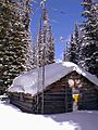
No cars or motor vehicles can reach Aneroid Lake. But don't worry, there's a very popular hiking trail that leads right to it! Near the south end of the lake, you'll find a few private cabins. From the lake, you can clearly see a spot called Pete's Point. Aneroid Lake is one of the highest lakes in the Eagle Cap Wilderness, sitting at 7,500 ft (2,300 m).
Contents
Backcountry Skiing at Aneroid Lake
Aneroid Lake is surrounded by slopes that often get snow as early as October. This makes it a popular spot for backcountry skiing. Backcountry skiing means skiing in wild, unmarked areas, not on groomed slopes.
Some guided tours are available for skiers. These tours sometimes use the cabins near the lake for overnight stays.
Safety in the Snow
The area around Aneroid Lake is known for unexpected avalanches. An avalanche is a sudden, fast-moving slide of snow down a mountain. Because of this danger, safety is very important when skiing here. Over the years, there have been accidents caused by avalanches. It's crucial for skiers to be aware of the risks and take proper safety measures.
Aneroid Lake SNOTEL Station

About half a mile east of Aneroid Lake, you'll find a special station called Aneroid Lake Snotel #2. This is one of two SNOTEL stations in the Eagle Cap mountains.
SNOTEL stands for "Snow Telemetry." These stations measure important things like how deep the snow is and how much water is in the snow. They also check general rainfall and the air temperature. The Natural Resources Conservation Service runs this station, which was set up in 1982. This information helps people understand snow conditions and water levels.
Hiking Trail to Aneroid Lake
You can reach Aneroid Lake by hiking from two different trailheads. These are the East Fork Wallowa River Trailhead or the Tenderfoot Trailhead.
The East Fork Wallowa River Trailhead is the shorter path to Aneroid Lake. It's only about 6 miles (9.7 km) long. This trail starts at the south end of Wallowa Lake, close to Wallowa Lake State Park. After hiking about 2 miles (3 km), you'll come to a small dam. Further along, at 3.8 miles (6.1 km), there's a well-built bridge. Then, at 5.5 miles (8.9 km), you'll reach Roger Lake. This trail is usually kept in good condition. It can be quite busy during the summer months, so you might see many other hikers!

Images for kids
-
Aneroid Lake SNOWTEL #2

