Angledool facts for kids
Quick facts for kids AngledoolNew South Wales |
|
|---|---|

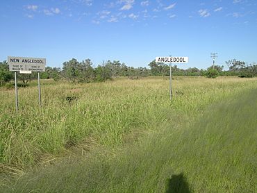
Boundary signs at (New) Angledool, NSW.
|
|
| Population | 58 (2016 census) |
| Elevation | 150 m (492 ft) |
| Location | 45 km (28 mi) N of Lightning Ridge |
| LGA(s) | Walgett Shire and Brewarrina Shires |
| County | Narran |
| State electorate(s) | Barwon |
Angledool is a small place in the upper western part of New South Wales, Australia. It is located near the southern border of Queensland. You can find it about one kilometre east of the Castlereagh Highway. It is also around 45 kilometres north of Lightning Ridge. In 2016, a count showed that 58 people lived in Angledool.
Contents
Angledool's Story
The Yuwaalaraay People
The Yuwaalaraay language is an Aboriginal language spoken in this area. It is also known by names like Yuwalyai or Euahlayi. The land where Yuwaalaraay is spoken includes places like Dirranbandi and Hebel in Queensland. It also stretches to Walgett and Collarenebri in New South Wales.
How Angledool Began
Angledool was first set up in the 1870s. Back then, it was called New Angledool. It started as a small settlement.
The Sparkle of Opals
In 1873, a man named Robert Moore made an exciting discovery. He was the manager of a large farm called Muggarie Station. He found opals, which are beautiful, colourful gemstones. Later, in 1908, another person named Charlie Dunstan found two very large opals. He named them the "Fire Queen" and "Queen of the Earth." These were found at the Angledool opal digging sites.
When the River Rises
The Narran River flows nearby, and it has caused floods in Angledool many times. Big floods happened in 1890, 1956, 1990, 1996, and again in March 2010. The flood in 1956 was the biggest one ever recorded. During the March 2010 flood, the Narran River filled up Angledool Lake. This lake covers a huge area of about 1,100 hectares when it is full. The water then flowed into Weetalabah Creek, which crosses the Castlereagh Highway. This helped fill up Coocoran Lake, which is near Lightning Ridge.
Angledool Through the Years
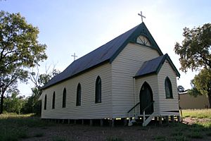
Before World War II, Angledool was a busy little village. It had a bakery, several hotels, a post office, and a court house. There was also a general store where people could buy supplies. Today, the village is much quieter. It has an old cemetery and a church. There are only a few houses left. Some buildings are more than 120 years old. The town hall is a great example of early local building. It was made from mud bricks from the area.
 | Misty Copeland |
 | Raven Wilkinson |
 | Debra Austin |
 | Aesha Ash |


