Aračinovo Municipality facts for kids
Quick facts for kids
Aračinovo Municipality
Општина Арачиново
Komuna e Haraçinës |
|||
|---|---|---|---|
|
Rural municipality
|
|||
|
|||
 |
|||
| Country | |||
| Region | |||
| Municipal seat | Aračinovo | ||
| Area | |||
| • Total | 31.3 km2 (12.1 sq mi) | ||
| Population | |||
| • Total | 12,676 | ||
| • Density | 370.51/km2 (959.6/sq mi) | ||
| Time zone | UTC+1 (CET) | ||
| Area code(s) | 02 | ||
| car plates | SK | ||
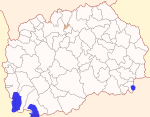
Aračinovo Municipality is a local government area in the northern part of North Macedonia. It is also known as Macedonian: Општина Арачиново in Macedonian and Albanian: Komuna e Haraçinës in Albanian. The main village and administrative center of the municipality is also called Aračinovo. This area is part of the Skopje Statistical Region.
Where is Aračinovo Municipality?
Aračinovo Municipality is located in a key spot. To its north, it shares a border with Lipkovo Municipality. To the west, it is next to the City of Skopje. Petrovec Municipality is to its south, and Kumanovo Municipality is to its east.
This municipality is considered a rural area. This means that all the places where people live within it are small villages. There are four villages in total in Aračinovo Municipality.
Who Lives in Aračinovo?
The number of people living in Aračinovo Municipality has grown over the years.
- In 1994, a national count showed there were 9,960 people.
- By 2021, the population had increased to 12,676 people.
Most people living in the municipality are Albanians. In 2021, about 97.45% of the population was Albanian. The remaining 2.55% included other ethnic groups.
| Demographics of Aračinovo Municipality | ||
|---|---|---|
| Census year | Population | |
|
|
||
| 1994 | 9,960 | |
|
|
||
| 2002 | 11,597 | |
|
|
||
| 2021 | 12,676 | |
The table below shows the ethnic groups in Aračinovo Municipality for 2002 and 2021.
| 2002 | 2021 | |||
| Number | % | Number | % | |
| TOTAL | 11,597 | 100 | 12,676 | 100 |
| Albanians | 10,879 | 93.81 | 12,353 | 97.45 |
| Macedonians | 596 | 5.14 | 7 | 0.06 |
| Bosniaks | 65 | 0.56 | 4 | 0.03 |
| Vlachs | 1 | 0.01 | ||
| Serbs | 10 | 0.1 | ||
| Other / Undeclared / Unknown | 46 | 0.38 | 2 | 0.01 |
| Persons for whom data are taken from administrative sources | 310 | 2.45 | ||
Villages in Aračinovo
As mentioned, there are four villages where people live in this municipality. The table below shows the population and ethnic makeup of each village in 2021.
| Inhabited Places | Total | Macedonians | Albanians | Turks | Roma | Aromanians | Serbs | Bosnians | Others |
| Aračinovo Municipality | 12,676 | 7 | 12,353 | - | - | - | - | 4 | 312 |
| Aračinovo | 7.991 | 4 | 7.777 | - | - | - | - | - | 210 |
| Grušino | 883 | 2 | 854 | - | - | - | - | - | 27 |
| Mojanci | 2.912 | 1 | 2.865 | - | - | - | - | - | 46 |
| Orlanci | 890 | - | 857 | - | - | - | - | 4 | 29 |
See also

- In Spanish: Municipio de Aračinovo para niños
 | James Van Der Zee |
 | Alma Thomas |
 | Ellis Wilson |
 | Margaret Taylor-Burroughs |


